fire science

Restoration of Forest Key to Fire Control, Expert Says

Dr. Trauernicht gives background on the wildfire issue in Maui and across the state. Credit: The Maui News

Great article on the wildfire issue in Hawaii based on a recent talk by our close partner, Dr. Clay Trauernicht of University of Hawaii CTAHR Cooperative Extension / Pacific Fire Exchange. Also, important identification of the need for more funding for forest restoration and fire prevention by another close partner of ours, Chris Brosius, program manager of the West Maui Mountains Watershed Partnership.

From the Source:

The causes of most fires are unknown. Out of 12,000 recorded incidents statewide from 2000 to 2011, only 882, or about 7 percent, had a determined cause. Of those, 72 percent were accidental, which also means they’re preventable, Trauernicht said at Wednesday’s meeting in the Pacific Whale Foundation’s classrooms in Maalaea. That’s why part of the solution is public education on the risks of fire and how to avoid sparking a fire.

That’s why it’s important to find ways to change the landscape to less sensitive and less flammable vegetation, he said. Statewide, non-native grasses and shrubland cover 25 percent of the total land; in Maui County, it’s 36 percent.

“Rather than trying to weed wack or spray to kill the grass, maybe you should think about a more permanent strategy, like planting trees to shade those grasses out,” Trauernicht said. “In other words, converting that vegetation to something that’s less likely to burn.”

“We can really only do two things,” Trauernicht explained. “We can target ignitions . . . and the only thing we have direct control over is the vegetation.”

“A lot of people think about jumping right into fuels management,” he said. “One of the big things is just having access and safer conditions and water for firefighters. So I think some of the more immediate things is ensuring they have the safest conditions.”

Study Links Climate Change to Increased Risk of Hawaii Wildfires

Credit: Dr. Clay Trauernicht

The need for more wildfire mitigation across Hawaii’s landscapes to protect natural resources and communities will only be greater with climate change. The time is now to take action!

This from our close colleague, a PFX coordinator, and a HWMO technical advisor, Dr. Clay Trauernicht, Wildfire Extension Specialist at University of Hawaii Manoa CTAHR.

From the Source:

The first study linking climate change to an increased probability of wildfires in Hawaiʻi also weighs the increased risks facing tropical regions around the world, according to University of Hawaiʻi at Mānoa researcher Clay Trauernicht.

Based on changes in rainfall and temperature due to climate change, the annual risk of wildfire could increase up to 375 percent for parts of Hawaiʻi Island, the analysis shows.

Lead researcher Trauernicht, of the College of Tropical Agriculture and Human Resources Department of Natural Resources and Environmental Management, tracked the “footprints” of historical fires on Hawaiʻi Island. His research shows how vegetation, ignition frequency and climate contribute to wildfire probability.

“The increased risk of fire stems from drought conditions due to low rainfall, as well as increased rainfall in the months prior to drought,” Trauernicht said. “This is because wet conditions mean greater growth of non-native grasses, which are the greatest fuel for wildfires in Hawaiʻi. Wet summer weather, combined with dry winter conditions, is characteristic of El Niño conditions and this winter looks likely to be another El Niño.”

Wildland Fire Danger Elevated in Hawaii with Drought in Forecast

From the Source:

For Hawaii, El Nino often translates into summer moisture followed by winter drought.

Drought conditions will be increasingly prevalent in the coming decades, said Clay Trauernicht, UH-Manoa wildland fire specialist and author of a study that examined how climate change will affect wildfires in Hawaii and tropical areas around the world.

The paper, published in Science of the Total Environment, not only discusses the effects of climate change on fire, but demonstrates how tracking rainfall patterns year to year can help better forecast near-term wildfire risk, including the danger that excess rainfall in advance of drought can pose to Hawaii’s vulnerable grasslands.

As for the current fire danger, Trauernicht said environmental conditions are quite similar right now to the period right before August, when a string of storms built up the fuel load and the drying islands were struck by a rash of wildland fires that burned nearly 30,000 acres.


Elizabeth Pickett, executive director of the Hawaii Wildfire Management Organization, said most people don’t realize the scale of Hawaii’s wildfire problem. Each year about 0.5 percent of Hawaii’s total land area burns, which is equal to or greater than the proportion burned of any other U.S. state, she said.

Pickett said 98 percent of wildfires are started by humans, most of them accidentally. People have to accept that we live in a fire-prone state and be extra careful to prevent fires, she said.

One common way to start a wildfire is from a spark or hot components of a motor vehicle. It’s the primary reason why Hawai‘i Volcanoes National Park closed Mauna Loa Road.

“By reducing the number of vehicles in high-risk areas, the park can mitigate the potential for a catastrophic event,” the park said.

Pickett said there are a number of simple things folks can do: Park cars on pavement and never on dry grass. Keep yards maintained and free of debris. Be careful with equipment that could spark. Practice family emergency plans.

More tips can be found at HawaiiWildfire.org/lookout.

A Warming Planet Could Trigger More Intense Wildfire Season in Hawaii

Credit: National Park Service

Over the last several years, HWMO has prioritized adaptive measures such as Firewise Communities and strategic, cross-boundary vegetation management planning to ready areas for the rapidly changing conditions causing more and larger wildfires in Hawaii. The gravity of the situation is real with climate change, but there is so much we can do in our own communities to prepare for wildfires and other climate hazards. Learn how by visiting our Take Action page and the Wildfire Lookout! page.

Check out this excellent article with some of our close partners, including Dr. Clay Trauernicht and Michael Walker, who were interviewed and data that HWMO was instrumental in laying the groundwork for — the statewide wildfire history database we produced with our fire agency partners. Although sobering, it is great to see this data put to use for a better understanding of how climate change affects Hawaii locally.


From the Source:

In Hawaii, wildfires generally ignite during the dry season, typically between May and November, when it's hotter, drier and windier outside.

But models show that the drier leeward areas, where fires are more frequent, will see even less rainfall as a result of climate change, exacerbating drought conditions and expanding the length of Hawaii's dry season.

That means more favorable conditions for brush fires to ignite.

And non-native grasslands and shrubs — which cover nearly a fourth of Hawaii's total land area — are highly adapted to fire, meaning they thrive when they burn and come back really quickly, researchers say. And the drier it is, the harder it is for forests to recover in those spots.

Hotter days could spell longer-lasting brush fires, meaning more hours for firefighters and greater potential for damage to infrastructure.

And it's only going to get hotter. A regional NOAA report estimates that in Hawaii, temperatures are expected to rise by 4 to 5 degrees by 2085 — under a worst case emission scenario.

"If you have hotter days, the conditions that are going to promote your most active fires — like the hottest, windiest conditions — have the potential to last longer for hours within a span of a day," Trauernicht said, pointing to the Makaha fire that continued burning in the early evening, when temperatures are normally dropping and humidity levels usually go up.

Fire Is the One Hawaii Disaster We Can Avoid

The August 2018 wildfires in Waianae Valley. Credit: Clay Trauernicht

An excellent article by Dr. Clay Trauernicht, wildland fire specialist of University of Hawaii CTAHR Cooperative Extension and Pacific Fire Exchange.

Not only does he explain why wildfires in Hawaii have burned 30,000 acres in August 2018, (more than double the annual average), but that it was predictable and there is much people can do to prevent wildfires. Dr. Trauernicht specifically sites the Wildfire LOOKOUT! tips for wildfire prevention.

To learn more about what you can do to protect your home and community from wildfire, visit HawaiiWildfire.org/lookout

From the Source:

Vegetation may be the most problematic issue facing fire management in Hawaii. Simply put, our communities and forests now exist amid an ocean of fire-prone grasslands and shrublands — about a million acres statewide. This is mostly a consequence of benign neglect as the value of real estate outweighs the value of maintaining production landscapes. Our agricultural and ranching footprint has declined by more than 60 percent across the state….

So what can we do about it? Awareness and education is the first step. Multiple state and county agencies and non-profits are working on this via the Hawaii Wildfire Lookout! Campaign, spearheaded by the Department of Land and Natural Resources and Hawaii Wildfire Management Organization. Fire prevention education can reduce accidental fires. Homes can be “hardened” to reduce the risk of loss. Communities can become “firewise” and organize to take actions such as increasing access for firefighters and reducing hazardous fuels near homes.

Vegetation is in some sense the simplest issue to tackle because it is the only fire hazard we can directly manage.  Yet it is also the most challenging due to the scale of the problem — the million acres of grasslands and shrublands across the state. There are multiple solutions for reducing risk in these fuels: fuel breaks, targeted grazing, prescribed fire, the restoration of agricultural and native ecosystems. There are also regulatory measures that can help such as firewise building and development codes.

Check out this letter to the editor from a former Firewise Co-Chair for Launiupoko, Ms. Linda Jenkins, who talks about their Firewise outreach efforts as a pathway forward.

”We completed assessments and provided all our neighbors with tips on how to make their homes and properties fire wise. An extensive public education campaign was conducted and we received our Firewise certification. We circulated tips on how to build a home and lay out a property to reduce fire risk. We also circulated tips on how to make your existing property and already built home safer.

This was successful in that many people made simple changes to their properties. I was also on the board at Makila and we maintained the sides of the bike path to create a fire break and kept our grass verges green.”

Drought in West Hawaii Increases Risk of Wildfires Running Rampant Already

"North Kona, seen from the Highway 190 scenic lookout, is brown and dry from the ongoing drought." (Laura Ruminski/West Hawaii Today)

Did you know 99 percent of wildfires in Hawaii are started by people? This West Hawaii Today article written by reporter Max Dible, explores the effects of drought on wildfire. 

Check out HawaiiWildfire.org/lookout for tips on what you can do to help protect your home and family from wildfire.

From the Source:

Tamara Hynd, program and operations assistant with the Hawaii Wildfire Management Organization, said wildfires have already burned through roughly 34,000 acres across the state, more than double the yearly average of 17,000 with more than four months of a dry year yet to go.

“Drought always plays a factor because the longer it goes on, the more intense it gets,” she said. “Your larger fuels begin to dry out more and more.”

Some advice she offered to mitigate risk is to avoid parking on dry grass because heat from exhaust systems can ignite it, or to keep heavy machinery like welding equipment and weed whackers away from dry areas, as such work can result in sparks that start fires.

Hynd said it was repair to heavy equipment that was the catalyst for the wildfire that ignited in Volcano earlier this month.

People who keep their grass short, their rain gutters free of debris and who have a water source and/or fire extinguisher on hand are also less likely to cause accidental wildfires, she said.

How California's Record Wildfire Season Paved the Way for Catastrophic Mudslides

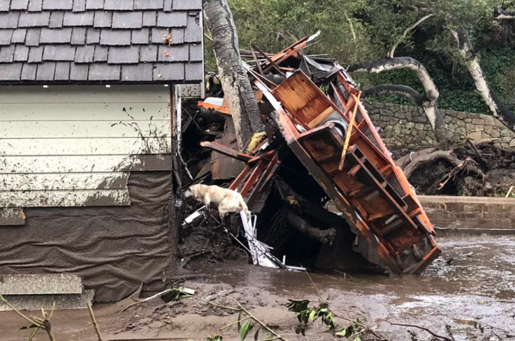
"Santa Barbara County Fire search dog Reilly looks for people trapped in the debris left by devastating mudslides in Montecito, California." Credit: Mike Eliason/Santa Barbara County Fire

As we keep all those affected by the mudslides and flooding in California in our thoughts, we should note that post-fire flooding can impact islands in the Pacific, as well. The characteristics that lead to these events are similar whether in California or in Hawaii.

From the Source:

"Also called post-fire debris flows, these mudslides form when water rushing down slopes picks up dirt, burnt trees, rocks, and other debris (like cars), reaching speeds of more than 35 miles per hour. “When you mix a lot of mud, water, and boulders, it certainly can be quite catastrophic,” says Dennis Staley, a scientist with the US Geological Survey Landslide Hazards Program. The slurries can start with almost no warning after as little as a third of an inch of rain in just 30 minutes — especially on slopes scorched by fires. After fires blazed across more than half a million acres this fall in California’s worst fire season on record, it’s not hard to find burnt land."

Fire makes slopes more susceptible to mudslides for a few reasons, according to climate scientist Daniel Swain’s Weather West blog. For one thing, flames can strip hillsides of plants that would otherwise anchor the dirt in place. Extreme fires that burn through thick vegetation can also physically change the soil — leaving behind a layer of water-repellant dirt near the surface. That layer acts like a raincoat, slicking off water that can then form mudslides, according to the USGS California Water Science Center.

Plus, without plants to slow the rain before it reaches the dirt, the soil can’t absorb as much water — leaving more to race down hillsides as runoff. Imagine the soil as coffee grounds in a filter: if you pour your boiling water slowly, it will soak into the grounds and drip through into your cup. But if you dump your boiling water all at once, a watery, muddy slurry will overflow. That’s what’s happening on the bare slopes of Southern California right now."

HWMO Highlight on the Conversation

Credit: National Park Service

Thank you to The Conversation on HPR for highlighting the wildfire issue and having HWMO's Elizabeth Pickett as a guest on the show! Peak wildfire season is not over (and in Hawaii, fire season is all year long) so stay vigilant, have a plan, and evacuate early.

From the Source:

"Hawaii has its own problem with wildfires, and each summer seems to bring a rash of fires that are mostly caused by people – some accidental, many of them deliberate. The Hawaii Wildfire Management Organization compiles the available data about each year’s wildfires."

Wildfire Burns Across (Formerly) Icy Greenland

The Sentinel-2 satellite captured a wildfire burning in western Greenland. Credit: Pierre Markuse Flickr (CC BY 2.0)

It's all connected!

From the Source:

"A series of blazes is burning roughly in the vicinity of Kangerlussuaq, a small town that serves as a basecamp for researchers in the summer to access Greenland’s ice sheet and western glaciers. The largest fire has burned roughly 3,000 acres and sent smoke spiraling a mile into the sky, prompting hunting and hiking closures in the area, according to local news reports."

"The ice has been melting at a quickening pace since 2000, partly due to wildfires in other parts of the world. The uptick in boreal forest fires has kicked up more ash in the atmosphere where prevailing winds have steered it toward the ice sheet.

The dark ash traps more energy from the sun, which has warmed the ice sheet and caused more widespread melting. Soot from massive wildfires in Siberia caused 95 percent of the Greenland ice sheet surface to melt in 2012, a phenomenon that could become a yearly occurrence by 2100 as the planet warms and northern forest fires become more common."

This is How Much of the World is Currently on Fire

"September 2014 Happy Camp Complex Fire in the Klamath National Forest in California." Credit: US Forest Service

These interactive maps and graphics offer a grim look at what we might expect as a new normal with climate change. The world is on fire like never before this year. Hawaii is no exception.

From the Source:

"Here in the United States the Forest Service is reporting that 2017 is shaping up to be a worse than average fire year based on acres of federal, private and state land burned. So far, 5.6 million acres of land has burned this year, or 1.8 million acres more than the ten year average of 3.8 million acres burned by this time."

"Across the border from the United States, fires are also currently scorching Canada’s British Columbia. This is the province’s second worst fire season on record and NASA satellites have identified the conflagration from space."

"On the other side of the globe, if you load up the European Commission’s fire map, it looks like the end of the world, especially in Italy and Romania. So far, an area just slightly smaller than the state of Rhode Island has burned. The total is already roughly three times the normal amount of summer wildfires. Back in June, 60 people died over the course of one weekend in Portugal due to wildfires. Thirty people were killed when the fires reached roads on evacuation routes. And as the map makes clear, those fires don’t seem to be abating, in part because of the hotter, drier temperatures."

Devastating California Detwiler Fire Can Be Seen From Space

Screenshot - Geostationary Operational Environmental Satellite R Series via Storyful

Satellites have many uses and functions. Did you know they could also aid in firefighting?

From the Source:

"One of the largest recent fires in California has been the Detwiler fire. Since it began on July 16, the blaze has burned across 80,000 acres, destroyed 63 residences, and threatened nearly 1,500 more. Thousands of people have had to evacuate their homes, more than 2,000 firefighters have been deployed, and the fire has also come perilously close to Yosemite National Park."

"The images are not quite like those from a typical camera or what one would see with the naked eye if one were circling the Earth. The special images are instead created by overlaying infrared images onto geocolor, the Earth-like colors produced by the 16 spectral bands aboard the satellite. GOES-R's images are essentially a heat map created using the satellite's different spectral bands to detect the fire's hot spots.

In addition to helping firefighters monitor blazing fires, GOES-R has also been used to monitor other potentially disastrous weather. Earlier this month, the satellite captured images of three tropical storms in the eastern Pacific, tornado cells in Iowa, and a solar eruption."

Beach Party for Wildfire Awareness in Kona Kicks Off Wildfire Season

Beach Party for Wildfire Awareness. Credit: Hawaii DLNR

We are excited to say that not only was HWMO's Beach Party for Wildfire Awareness a success on May 6, but it also received statewide media attention. One of the highlights of the event was the official launch of Wildfire Lookout!, a multi-partner coordinated statewide wildfire prevention and preparedness campaign. Mahalo to KHON2, KITV, and Big Island Video News for coverage of the event, and a very special mahalo to Department of Land and Natural Resources for documenting the day's proceedings and sharing with the media.

From the Sources:

"'In the end, all of us are impacted by wildfire. It’s just that some of those impacts are more invisible than others, so people aren’t quite as aware,' Elizabeth Pickett, executive director of the Hawaii Wildfire Management Organization, said.

Pickett says over 25-percent of the state has been invaded by non-native, fire-prone grasses and shrubs.

That percentage grows as fires consume native forests which are then taken over by those invasive species." - KHON2
 

"The importance of land and homeowners to be fire ready is the theme of National Community Wildfire Preparedness Day events and activities across the country today. At the Old Kona Airport State Recreation Area on Hawai‘i Island’s west side, Elizabeth Pickett watched as several non-profit organizations set up booths and exhibits for the first-ever Beach Party for Wildfire Awareness. Pickett is the executive director of the Hawai‘i Wildfire Management Organization (HWMO), which with DLNR, and two dozen other State and federal government organizations and various non-profits are supporting the second year of a public and media awareness campaign: Wildfire LOOKOUT!

Pickett explained to people who dropped by the HWMO booth, that just because they may never have personally experienced a wildfire close to their home or property, that doesn’t mean they weren’t impacted. She explained, “Especially in our island environment the negative impacts of a wildfire in a specific location usually has detrimental impacts many miles away that can persist for years and even decades. You often hear people refer to 'mauka to makai,' and that effect pertains to wildfire. Once land is stripped of trees and vegetation it becomes much more prone to erosion and the introduction of invasive species and soot and sediment can wash from mountain forests to the sea where it can choke out life in coral reefs.'

Big Island State Representative Cindy Evans emphasized the need for everyone in Hawai‘i to become aware of these impacts and to do their part to prevent wildland fires. She’s seen first- hand the devastation and destruction, these often fast moving fires cause. Evans said, 'Even the loss of one home is one too many when you consider that with a little awareness, people truly can prevent wildland fires.'" - Hawaii Department of Land and Natural Resources (picked up by Big Island Video News)

What's the Leading Cause of Wildfires in the U.S.? Humans

"More than 10 wildfires burned over 200,000 acres in Southern California in October 2003, many of them started by humans. This satellite image shows strong winds carrying smoke over the Pacific." Credit: MODIS Rapid Response Team/NASA

It is no surprise, human beings are the leading cause of wildfires in the U.S. (more than 98% of fires in Hawaii are caused by people). But now, thanks to scientists, we know the extent of the issue: humans cause 84% of forest fires nationwide! Prevention education is so important - we hope that you can continue to help HWMO spread the word about preventing wildfires to protect our communities, lands, and waters. 

From the Source:

"As a result, Balch says, not only are people causing the vast majority of wildfires, they're also extending the normal fire season around the country by three months."

"I think acknowledging that fact is really important," she says, "particularly right now when we have evidence that climate is changing, and climate is warming, and that fires are increasing in size and the fire season is increasing."

Risk of 'Megafires' to Increase as Climate Warms

Scientists, using new imaging technology aboard two NASA satellites, predict that indeed a warming planet will lead to...more 'megafires.' With more and longer drought periods predicted for Hawaii on both the wet and dry sides, our islands will also most likely experience an increase in wildfire occurrence and severity as the climate changes. 

Projected changes in the number of days exceeding the 93rd percentile of the Fire Weather Index (FWI) by the mid 21st century (2041-2070) under a high emissions scenario (RCP8.5). Dark red shading indicates the largest increases, while the pale green hows small decreases. Red triangles and blue dots show recent extreme wildfire events as per previous figure. Source: Bowman et al. (2017)

From the Source:

"Recent research shows that the number of days wildfires are likely to burn each year is increasing as global temperatures rise. And the new study finds that extreme wildfires are likely to become more widespread in future, Bowman says:

'Climate change projections suggest that the geographic footprint of dangerous fire weather is likely to expand globally.'"

"The findings make a compelling case that adds to the mounting evidence on the increasing risk of wildfires, adds Giglio:

'Clearly on the current path we can expect a greater risk of extreme fires in much of the world. The outlook for the western United States is particularly worrying.'

While the publication of this study on the anniversary of Black Tuesday is a 'fortuitous coincidence', says Bowman, it highlights that the combination of cities surrounded by flammable forests and increasing wildfire risk 'will lead to more fire disasters'.

Lightning, Tornadoes and Mice: The Science Behind Bushfires

Flickr.com: Bert Knottenbeld

Even though Australia is miles away from Hawaii, there are many commonalities with how wildfires (or bushfires, as they call it) behave on the continent versus Hawaii. Here’s a great article that explains how bushfires work — see if you can draw the parallels with Hawaii. The main difference? Wildfire is part of a natural cycle in Australian ecosystems, unlike in Hawaii where it is an introduced cycle.

From the Source:

“Peak fire conditions occur when there's a period of significant rainfall that causes plants to grow, followed by a hot spell that dries out this fuel. This means the bushfire seasons vary around Australia.”

“Bushfires typically move in a front — a thin line of burning grass or forest that inches forward as new material catches alight.

Radiant heat from the fire front warms the air ahead, drying out fuel, and causing volatile gases inside wood to escape – thus priming new fuel for the approaching fire.”

“Strong winds can sometimes blow burning embers ahead of the fire front, setting alight new patches of fuel in a process known as "spotting".

These patches of fire can then quickly grow and join up, forming one giant blaze, hundreds of metres or even kilometres wide. Such an event, known as "deep flaming", is more difficult for firefighters to control.

The heat and smoke given off from deep flaming can even create "pyrocumulonimbus" clouds that form over a bushfire.”

“'Different species have different life cycles, and some of their aspects of reproduction and regeneration may be linked to fire,' Professor Bradstock said.

An example of such a plant is the acacia, which requires the heat of a bushfire to crack its seed pods so it can germinate.”

When Spark Meets Sprawl: Building in Wildlands Increases Fire Risk

Sand Fire. (Credit - Center for Investigative Reporting)

An incredibly thorough and comprehensive Center for Investigative multimedia article with many facts, figures, maps, images, and soundbites that is definitely worth checking out! This is the article to read if you want to learn more about the current state of the "Wildland-Urban Interface (WUI)" and the continuing risks developing into the wildlands presents for communities and our natural resources.

From the Source:

"Nationally, more than a third of new homes built since 2000 are in WUI areas. What has happened, wildfire historian Stephen J. Pyne wrote in 2008, is that we’re “leaving natural growth alone and then stuffing the openings with combustible structures.”

“Stephen J. Pyne, the wildfire historian, said that unless there’s coherent and coordinated policy that looks at development and forest management, these problems will be difficult to solve.

‘Otherwise, you’re just in the whack-a-mole mode and you’re not going to win,’ Pyne said. ‘In cities, every fire you put out is a problem solved. In wildlands, every fire you put out is a problem put off.’”

As Peat Bogs Burn, A Climate Threat Rises

"A peat sample showing the history of wildfires dating back hundreds of years. Scientists can trace the history of wildfires to better understand how the peat land acts as a carbon sink." (Ed Ou/New York Times)

Did you know that peatlands make up about 3 percent of the earth's land surface, but contain more carbon cumulatively than all of our trees and plants on this Earth? Can you imagine if these areas go up in flames? Check out this very interesting New York Times piece about the effect climate change is having on our peatlands and the potential for a shockingly immense amount of carbon release. 

From the Source:

“They take thousands of years to develop,” said Merritt Turetsky, a peat researcher at the University of Guelph in Ontario. “And in five minutes, a wildfire can blow through that area and release five to six hundred years of peat accumulation and change it forever.”

“Drier peat allows more oxygen to get to the roots of trees and other vegetation. This causes them to grow bigger, which means they use more water, further drying the peat.

As trees grow, they also provide more shade, which favors the growth of other mosses that, because they hold less moisture than sphagnum, are less fire resistant.

When the bog does catch fire, it may be more severe, with the combustion spreading deeper into the peat.”

Watch Out for Wildfires

Currently there are several updates to Community Wildfire Protection Plans in the works, as well as new plans being developed.

Mahalo to The Garden Island for the nice feature on the wildfire situation in Kauai and the Community Wildfire Protection Plans (CWPPs) that HWMO has been working.

From the Source:

“Don’t be fooled by the rain we might get and think we’re off the hook,” said Elizabeth Pickett, executive director of Hawaii Wildfire Management Organization, a nonprofit that’s dedicated to spreading wildfire education. “Rain makes more vegetation grow, that dries out and then there’s more fuel for wildfire.”

Pablo Beimler, HWMO coordinator, said with the extensive drought period the state experienced earlier this year, and the EL Nino phenomenon that’s in effect “could spell trouble in the number of ignitions and the sizes.”

In preparation for that dry summer, HWMO has been working on six Community Wildfire Protection Plans, which outline the wildfire hazard sand issues each specific community faces, the organizations and entitles that have a stake in wildfire management, and how they can work together to minimize the number and sizes of wildfires this season.

Organizations Kick Off Wildfire and Drought Look Out! Campaign

Credit - Molly Solomon/HPR

HWMO and its partners statewide worked together to launch Wildfire & Drought Look Out!, Hawaii's first coordinated statewide wildfire outreach campaign. Here are a number of news clippings from TV, radio, and newspaper sources and the links to each source.


KHON2:

“‘I have been preparing for it for years now,’ said Momoa. ‘Ever since I moved in there, I could see the vision that it was going to burn soon.’”

Big Island Now:

“‘We have set up both a public and a media page on the HWMO website. The public page will have loads of information for home and property owners on how best to prepare for the possibility of wildfire well in advance,’ said HWMO Executive Director Elizabeth Pickett. ‘We’ll include water saving information which is really topical during this prolonged drought event in many areas across the state, largely caused by El Nino weather conditions.’

HWMO will also maintain and manage a media page, where partners can contribute story ideas and leads for reporters and their news organizations.”

Maui News:

“Prevention suggestions include:

* Clearing combustible materials near homes and lanais.

* Keeping grass short and tree branches off of the ground.

* Creating a defensible space at least 100 feet around a home.

* Removing leaves and debris from gutters and roofs.

* Covering eaves and vents with -inch mesh.

* Creating and practicing a family evacuation plan.”

HPR:

“With an above-average fire season ahead, state officials stress a need for public awareness. Hawai‘i Wildfire Management Organization is a nonprofit that’s working with federal, state and local agencies to kick start a campaign to provide information and tips for homeowners. More information can be found on their website, hawaiiwildfire.org.”

Honolulu Civil Beat:

More than 60 percent of the state is experiencing moderate drought conditions, and parts of the Big Island are facing extreme drought, according to the U.S. Drought Monitor.

Credit - Clay Trauernicht

“We hope this campaign, which has both a public and a media component, will educate and inform everyone living in and visiting Hawaii about the year-around threat of wildfires,” DLNR Director Suzanne Case said in a release.

Hookele News:

“The campaign seeks to educate homeowners and communities and empower them to take proactive steps that reduce the chances of wildfire ignition and create safer conditions for our firefighters.”


Hawaii Faces Increased Wildfire Risk This Summer

Nationally, Hawaii is on the map this year (along with Alaska and the Southwest) as being an area of "increased danger for significant wildland fires from May through August" according to a new report from the National Interagency Fire Center.

Our partners Clay Trauernicht, from University of Hawaii CTAHR Cooperative Extension, and Captain David Jenkins, from Honolulu Fire Department, do a great job in this Hawaii News Now report to explain the current drought and wildfire situation and what that means for Hawaii visitors and residents.  Stay tuned for the statewide wildfire prevention and preparedness campaign set to launch real soon!

From the Source:

'We've sort of been tracking the progression of the drought, so we're pretty well aware that we're facing an above-average fire season for the summer,' said Clay Trauernicht, a wildfire specialist with the University of Hawaii Cooperative Extension.

'We're seeing reports of El Nino subsiding, but what that means for us is, it's sort of leading us right into our summertime dry season. So even though it's going to look like a normal summer, we have this big rainfall deficit from the wintertime,' Trauernicht said.

Several agencies are working together and will soon be launching a new wildfire prevention and preparedness campaign to help keep communities safe.

'There's a lot of things you can do both to prevent fires from starting, as well as reducing fire risks around your homes,' Trauernicht said."