floods

Repeated Natural Disasters Pummel Hawaii’s Farms, Affecting Macadamia Nuts, Taro, Papaya, Flower Harvests

“An image by NOAA’s GOES-15 satellite shows Hurricane Lane when it was about 300 miles south of Hawaii's Big Island on Aug. 22. (National Oceanic and Atmospheric Administration/EPA-EFE/Shutterstock)”

Farmers in the Pacific on the front-lines of climate-related natural disasters such as cyclones and wildfires. We must do all we can to ensure our farmlands are protected from these growing threats to our food and people’s livelihoods.

If you are a farmer or own/operate large lands in Hawaii and other Pacific Islands, check out the Pacific Fire Exchange pre-fire planning resources: http://www.pacificfireexchange.org/research-publications/category/pre-fire-planning?rq=pre-fire%20plan

From the Source:

As Hawaii begins to recover from the tropical cyclone that dumped more than three feet of rain onto the Big Island last week, farmers here are just starting to assess the damage to their crops. Lane landed yet another blow to Hawaii’s agriculture industry after an already difficult year of reckoning with Mother Nature. Flooding, excess moisture and pounding rains could hurt macadamia nut, coffee and flower harvests for farmers on the east side of the island, which bore the brunt of the storm.

Lane also impacted small farms on the island of Maui, where the storm’s winds fanned and spread wildfires across hundreds of acres in Lahaina.

In the days leading up to the hurricane, beekeeper Eldon Dorsett prepared his bee hives for the coming weather, putting heavy weights on the top of the boxes to keep them from blowing away.

Dorsett arrived at the farm Saturday morning and found 15 of his hives burned to a crisp — the only evidence of their existence was a few nails and screws on the still-smoldering ground.

“It was a rough day,” Dorsett said. “The farm was like the day after Armageddon.”

“No matter what happens, we need to keep moving forward,” said Haraguchi-Nakayama, whose family operates Hanalei Taro. “People in Hawaii are resilient by coming together as a community during times of crisis. Farmers are vulnerable to so many things beyond our control. Farmers need to be resilient in order to continue farming.”

How California's Record Wildfire Season Paved the Way for Catastrophic Mudslides

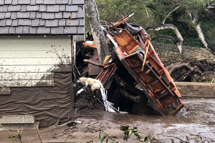
"Santa Barbara County Fire search dog Reilly looks for people trapped in the debris left by devastating mudslides in Montecito, California." Credit: Mike Eliason/Santa Barbara County Fire

As we keep all those affected by the mudslides and flooding in California in our thoughts, we should note that post-fire flooding can impact islands in the Pacific, as well. The characteristics that lead to these events are similar whether in California or in Hawaii.

From the Source:

"Also called post-fire debris flows, these mudslides form when water rushing down slopes picks up dirt, burnt trees, rocks, and other debris (like cars), reaching speeds of more than 35 miles per hour. “When you mix a lot of mud, water, and boulders, it certainly can be quite catastrophic,” says Dennis Staley, a scientist with the US Geological Survey Landslide Hazards Program. The slurries can start with almost no warning after as little as a third of an inch of rain in just 30 minutes — especially on slopes scorched by fires. After fires blazed across more than half a million acres this fall in California’s worst fire season on record, it’s not hard to find burnt land."

Fire makes slopes more susceptible to mudslides for a few reasons, according to climate scientist Daniel Swain’s Weather West blog. For one thing, flames can strip hillsides of plants that would otherwise anchor the dirt in place. Extreme fires that burn through thick vegetation can also physically change the soil — leaving behind a layer of water-repellant dirt near the surface. That layer acts like a raincoat, slicking off water that can then form mudslides, according to the USGS California Water Science Center.

Plus, without plants to slow the rain before it reaches the dirt, the soil can’t absorb as much water — leaving more to race down hillsides as runoff. Imagine the soil as coffee grounds in a filter: if you pour your boiling water slowly, it will soak into the grounds and drip through into your cup. But if you dump your boiling water all at once, a watery, muddy slurry will overflow. That’s what’s happening on the bare slopes of Southern California right now."

Mudslide and Flood Threat Prompts Evacuations in Burnt Southern California as Major Storm Looms

"A Los Angeles County Sheriff's deputy alerts a Kagel Canyon resident of mandatory evacuations on January 8, 2018 in the Creek Fire burn area." Credit: LA County Sheriff's Office

Whether in Hawaii or California, post-fire erosion and flooding is a big deal. For example, the 2016 floods in Maui after an explosive fire season created massive plumes of soil, debris, trash, oil, and other pollutants along the shorelines. We are crossing our fingers that the post-fire flood threat in California this week will spare all homes and people in its path and have minimal damage throughout the watersheds.

From the Source:

"The mandatory evacuation order was issued for unincorporated parts of Santa Barbara County, Montecito, Summerland and Carpinteria, the county said. Areas along Tecolote Canyon, Eagle Canyon, Dos Pueblos Canyon, Gato Canyon, and Whittier burn areas near Goleta were also included in that order."

“This is the first significant rain the area has had in some time, it’s the first where they’ve had to be concerned about the fire scarred areas of the hills,” he added. Lucksinger said flooding and mudslides were always a concern in the foothills and mountains “when rain comes down quickly in a short amount of time like that.”

Firefighters Battle Wildfires Across the Western U.S. and Canada

TIME video screen capture

Another day to be thankful for firefighters and all they do in yet another busy wildfire season across the continent. Remember to GO! early if I fire is in your area. Leaving early alleviates traffic jams, creates safer access for firefighters, and prevents valuable first response resources from being used for search and rescue efforts. Hawaii residents, more information available in the Ready, Set, Go! Wildland Fire Action Guide and Wildfire Lookout!  

"Firefighters on Monday made progress against wildfires burning across numerous states in the hot, dry West.

That included California, where slightly cooler temperatures and diminishing winds helped firefighters as they battled several wildfires that have forced thousands to flee their homes in both ends of the state."

Advancing FAC in Hawaii: Increasing Awareness, Thinking Both Short and Long Term and...Goats?

Click to Read the Blog Post

In 2015, we began working with several communities statewide on grassroots-level community wildfire protection efforts, primarily through Firewise’s communities recognition program. Only a few years later, we’re happy to say that our communities are seeing some great success! Find out how HWMO and its partners are working with communities to advance Fire Adapted Community goals in the latest highlight on the FAC Learning Network blog.

From the Source:

"These recommendations have already encouraged Firewise committees to start thinking outside of the box. For example, two years ago, Waikoloa Village received a fuels reduction grant from the USDA Forest Service. The village used the funds to hire a goat-grazing contractor to reduce flammable vegetation on vacant lots. As phase two of the project, the community will be installing permanent fence posts to allow for more regular grazing. Eventually, they may transform these lots into a multi-use area where goats continue to graze and the community also grows citrus trees.

These communities are also engaging residents through outreach. A few months ago, the Launiupoko Firewise committee sent over 300 copies of ReadySetGo! Wildland Fire Action Guides to residents. This spring, they will be hiring a contractor to remove flammable vegetation along an established bike path. Kahikinui, a small homestead in one of the most remote areas on Maui, worked tirelessly last year to engage neighboring large landowners and various agencies in their Firewise efforts. Their persistence and creativity led to a collaborative fuels mitigation project that received funding from the Department of Hawaiian Homelands and a local wind farm."

Dealing with Wildfires in North Hawaii

HWMO, along with its fire agency partners, are highlighted in this week's edition of North Hawaii News! Get the inside scoop on what it took to fight the challenging Kawaihae Fire last month from those who were on the front lines. You'll also find some of the work HWMO is doing to keep wildfire occurrences and destructive effects to a minimum. 

Aftermath of Kawaihae fire that burned from makai to mauka. (Pablo Beimler/HWMO)

From the Source:

"With fewer per capita emergency resources than higher populated areas like Honolulu, HFD has to make strategic use of available resources to cover large geographic areas on challenging terrain. Communication, coordination among units, planning, training, equipment and following well-established priorites are crucial, according to Captain Sommers."

"Pablo Beimler, education and outreach coordinator for Hawaii Wildfire Management Organization (HWMO), has created a compelling video vividly depicting the Kawaihae wildfire’s cumulative damage to coastal areas. It can be viewed at https://www.youtube.com/watch?v=0kNo7Ucv28Y.

With this month’s fire coming close to the ocean, HWMO’s Executive Director Elizabeth Pickett says, “'Most residents do not readily connect wildfire to coastal impacts because there is frequently a lag time and often geographic distance between fires and storm events.'"

VIDEO: Flash Flooding Near Kawaihae Filmed

Screen capture from Big Island Video News.

On Monday, August 17th, a storm brought heavy rainfall to the State, including the Northwest side of Hawaii Island. Inches of rain fell each hour, which as you can imagine created frightening flash flood scenarios. Highways were shut down, vehicles were stranded, and dozens of residents evacuated the Kawaihae area. An unprecedented amount of murky stormwater ran through the streams and streets of Kawaihae and as of this morning, continues to find routes to the ocean. 

These shocking videos show just how dramatic the post-fire erosion event was last night.