natural resource protection

750 Trees Find New Homes in the Mountains of Waianae

“Dozens of volunteers got down and dirty to plant roughly 750 trees on Oahu’s west side.” Credit: DLNR.

Important work being done by our partners from the Waianae Mountains Watershed Partnership and DLNR to reforest Waianae Kai State Forest Reserve, which will create a more resilient landscape and reduce the wildfire risk in the area. If you want to get involved with the planting events, you’re asked to contact coordinator Yumi Miyata at (808) 227-9545, or wmwpcoordinator@gmail.com.

From the Source:

“The Enterprise Urban Tree Initiative brings our employees together to volunteer in communities like Waianae that have been devastated by natural disasters, such as wildfires,” said Chris Sbarbaro, Enterprise Hawaii Vice President of External Affairs. “We support the Arbor Day Foundation and its partners in their efforts to build strong communities from the ground up and create a sustainable and inclusive future for all.”

The need to restore Oahu’s west side comes as a dry spell started to hit Nanakuli, and is likely to move toward Waianae during the normally hot and dry summer months.

“Unfortunately, wildfires have become more frequent in Waianae. The cycle of infrequent, heavy rain followed by dry, hot and windy weather creates the perfect conditions for fast-moving, intense fire. A recent fire in August 2018 burned more than 1,500 acres of the forest reserve, threatening native forests important for water recharge,” said Yumi Miyata, Waiʻanae Mountains Watershed Partnership Coordinator and Chair of Hawaii Association of Watershed Partnerships.

Restoration of Forest Key to Fire Control, Expert Says

Dr. Trauernicht gives background on the wildfire issue in Maui and across the state. Credit: The Maui News

Great article on the wildfire issue in Hawaii based on a recent talk by our close partner, Dr. Clay Trauernicht of University of Hawaii CTAHR Cooperative Extension / Pacific Fire Exchange. Also, important identification of the need for more funding for forest restoration and fire prevention by another close partner of ours, Chris Brosius, program manager of the West Maui Mountains Watershed Partnership.

From the Source:

The causes of most fires are unknown. Out of 12,000 recorded incidents statewide from 2000 to 2011, only 882, or about 7 percent, had a determined cause. Of those, 72 percent were accidental, which also means they’re preventable, Trauernicht said at Wednesday’s meeting in the Pacific Whale Foundation’s classrooms in Maalaea. That’s why part of the solution is public education on the risks of fire and how to avoid sparking a fire.

That’s why it’s important to find ways to change the landscape to less sensitive and less flammable vegetation, he said. Statewide, non-native grasses and shrubland cover 25 percent of the total land; in Maui County, it’s 36 percent.

“Rather than trying to weed wack or spray to kill the grass, maybe you should think about a more permanent strategy, like planting trees to shade those grasses out,” Trauernicht said. “In other words, converting that vegetation to something that’s less likely to burn.”

“We can really only do two things,” Trauernicht explained. “We can target ignitions . . . and the only thing we have direct control over is the vegetation.”

“A lot of people think about jumping right into fuels management,” he said. “One of the big things is just having access and safer conditions and water for firefighters. So I think some of the more immediate things is ensuring they have the safest conditions.”

Mauna Kea Fire Burning 110+ Acres Caused By Camp Fire

“A brush fire continues to burn off Daniel K. Inouye Highway Wednesday near near the Maunakea Access Road.” (HOLLYN JOHNSON/Tribune-Herald)

From the Source:

The fire, which broke out about 10 a.m. Tuesday in the northeastern corner of Pohakuloa Training Area, had burned about 110 acres of state and U.S. Army land as of Wednesday afternoon. It’s burning on the slopes of Mauna Kea, about 2 miles north of Daniel K. Inouye Highway and on the Kona side of Mauna Kea Access Road, said PTA spokesman Mike Donnelly.

“In the last 24 hours, these guys have done a remarkable job containing this fire given the brutal terrain that they’re in,” Donnelly said after observing the fire from a helicopter. The blaze is about 70 percent contained.

Apply for a Wildfire Community Preparedness Day Grant by March 1!

#WildfirePrepDay 2018 at Kamilonui-Mariner’s Cove in Hawaii Kai, Oahu. They received a State Farm grant for their vegetation reduction efforts and were able to go the extra mile because of it! Credit: Livable Hawaii Kai Hui

From our partners at NFPA:

Wildfire Community Preparedness Day this year it is May 4, 2019. NFPA® will again be offering project funding awards to 150 communities across the United States. Each of these $500 awards provided with past generous support from State Farm, can be used to complete a wildfire safety project where you live.

The application period for one of one hundred fifty $500 awards opens January 7 at 8 AM EST, and will close March 1 at midnight EST.  Winners will be announced March 22. 

Four Acre Alan Davis Beach Fire in East Oahu Extinguished

“Firefighters working to put out a brush fire on Oahu’s east side.” Credit: Hawaii News Now

The area of the fire is known for remnant native trees and plants that are a vibrant sight to see in Kaiwi. You can volunteer to be a part of the restoration efforts of this remarkable coastline here: http://kaiwicoast.org/volunteer.htm


From the Source:

Honolulu firefighters responded to a brush fire near Alan Davis Beach on Saturday.

Due to muddy off road conditions, crews were unable to access the fire with fire trucks.

“Personnel hiked in and initiated a ground fire attack in coordination with water drops from Air 1,” Fire Capt. Scot Seguirant said in a press release. “The Honolulu Police Department assisted with stopping beach goers from entering the burn area while they hiked to the beach from the lighthouse parking lot.”

El Nino Impacts Likely Through Winter, Into Spring - Higher Potential for Large Wildfires in Hawaii

“A Hawaii County firefighter monitors a brush fire.” (Laura Ruminski/West Hawaii Today)

El Nino means a higher potential for large fires throughout much of Hawaii. Be prepared by going through the Ready Set Go! Action Guide and WildfireLOOKOUT! materials — there are many ways to get involved and Take Action.

From the Source:

El Nino has more than one impact on water. It doesn’t just heat it up, it changes how much falls from the sky and when.

Matthew Foster, meteorologist with the National Weather Service in Honolulu, said NWS has forecast a 90 percent chance of El Nino in the winter and a 60 percent chance it persists into the spring.

According to North Ops Predictive Services, rainfall totals are projected below normal levels from December through the spring months assuming an El Nino takes hold and hangs around.

Because of this, and despite rainfall through last summer and fall that left green grass crop in several areas across the state, large fire potential is expected to increase to above normal levels from January to March.

“December was still neutral conditions,” Foster said, “(But) it would be expected drier than normal over the next few months.”

New Year’s Eve and Day were jointly characterized by three separate blazes in West Hawaii alone, two in the area of Waikoloa Village and one above Hawaiian Homes in Kawaihae.

Mauna Loa Road Closed To Cars Due To Very High Fire Danger

On December 13, volunteers remove koali ʻawa from Kīpukapuaulu (NSP Photo/Janice Wei)

From the Source:

The gate near Kīpukapuaulu parking area has been closed, as Mauna Loa Road has been declared off limits to motorized vehicles until further notice, due to a very high fire danger.

Hawaiʻi Volcanoes National Park officials on Monday said non-motorized day use such as hiking and bicycling will be permitted, and backcountry camping on Mauna Loa is still allowed with a permit.

Open fires, including charcoal cooking fires, are prohibited at the Kīpukapuaulu picnic area, and Kilauea Military Camp. Propane or gas cooking stoves are permitted, park officials say.

“The strong winds and dry weather over the past week has led to a rapid escalation of fire danger on Mauna Loa, and fire danger indexes have reached critical thresholds at the Mauna Loa weather station,” said Fire Management Officer Greg Funderburk.

The Naional Park Service says “hot components on motor vehicles have historically contributed to the increased risk of fire. By reducing the number of vehicles in high-risk areas, the park can mitigate the potential for a catastrophic event.”

Over the summer, a 3,739-acre wildfire on Mauna Loa threatened values park resources like the Kīpukakī and Kīpukapuaulu Special Ecological Areas, cultural heritage areas and rare forest habitat for endangered species. A coordinated effort managed to contain the blaze.

Fueling the Fire: Trump Thinks Logging Will Stop the Burning in California. It won't.

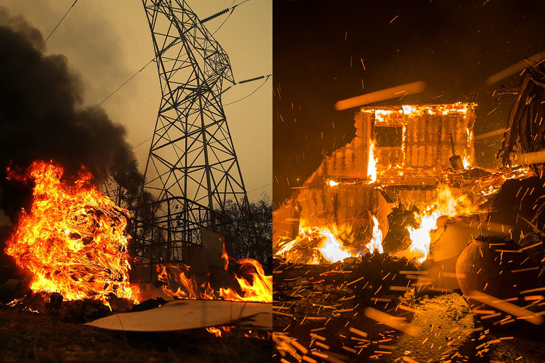
“On the left is the Camp Fire in Big Bend, California, and on the right the Woolsey Fire in Malibu, California.” - Credit: Justin Sullivan/Getty Images and David McNew/Getty Images

One of the most renowned wildland fire experts, Stephen J. Pyne, offers more than his two cents of why the California fires are as extreme as they are…and it is not because California has not removed enough trees.

From the Source:

Where fires are crashing into towns, the real fuel is the built environment. Aerial photos of savaged suburbs tend to show incinerated structures and still-standing trees. The vegetation is adapted to fire; the houses aren’t. Once multiple structures begin to burn, the local fire services are overwhelmed and the fire spreads from building to building. This is the kind of urban conflagration Americans thought they had banished in the early 20th century. It’s like watching measles or polio return. Clearly, the critical reforms must target our houses and towns and revaccinate them against today’s fire threats. The National Fire Protection Association’s Firewise program shows how to harden houses and create defensible space without nuking the scene into asphalt or dirt.

Too often, whether we’re talking about politics or fire management, the discussion ends up in absolutes. We leave the land to nature, we strip it, or we convert it to built landscapes. We have either the wild or the wrecked. In fact, there are lots of options available, and they will work best as cocktails. There is a place for prescribed burning, for prescribed grazing, for prescribed thinning (a kind of woody weeding), for prescribed chipping and masticating by machines, for greenbelting—crafting swathes of low-fuel land use like recreational parks or even golf courses—and, in select sites, for prescribed logging. Most treatments should concentrate where people and high-value assets are at risk—exurbs, suburbs, municipal watersheds. Elsewhere, in wildlands, some kind of managed fire will likely prove the most usable means, and in the West, hybrid practices—half suppression, half prescribed burn—are becoming common.

A Warming Planet Could Trigger More Intense Wildfire Season in Hawaii

Credit: National Park Service

Over the last several years, HWMO has prioritized adaptive measures such as Firewise Communities and strategic, cross-boundary vegetation management planning to ready areas for the rapidly changing conditions causing more and larger wildfires in Hawaii. The gravity of the situation is real with climate change, but there is so much we can do in our own communities to prepare for wildfires and other climate hazards. Learn how by visiting our Take Action page and the Wildfire Lookout! page.

Check out this excellent article with some of our close partners, including Dr. Clay Trauernicht and Michael Walker, who were interviewed and data that HWMO was instrumental in laying the groundwork for — the statewide wildfire history database we produced with our fire agency partners. Although sobering, it is great to see this data put to use for a better understanding of how climate change affects Hawaii locally.


From the Source:

In Hawaii, wildfires generally ignite during the dry season, typically between May and November, when it's hotter, drier and windier outside.

But models show that the drier leeward areas, where fires are more frequent, will see even less rainfall as a result of climate change, exacerbating drought conditions and expanding the length of Hawaii's dry season.

That means more favorable conditions for brush fires to ignite.

And non-native grasslands and shrubs — which cover nearly a fourth of Hawaii's total land area — are highly adapted to fire, meaning they thrive when they burn and come back really quickly, researchers say. And the drier it is, the harder it is for forests to recover in those spots.

Hotter days could spell longer-lasting brush fires, meaning more hours for firefighters and greater potential for damage to infrastructure.

And it's only going to get hotter. A regional NOAA report estimates that in Hawaii, temperatures are expected to rise by 4 to 5 degrees by 2085 — under a worst case emission scenario.

"If you have hotter days, the conditions that are going to promote your most active fires — like the hottest, windiest conditions — have the potential to last longer for hours within a span of a day," Trauernicht said, pointing to the Makaha fire that continued burning in the early evening, when temperatures are normally dropping and humidity levels usually go up.

Fire Is the One Hawaii Disaster We Can Avoid

The August 2018 wildfires in Waianae Valley. Credit: Clay Trauernicht

An excellent article by Dr. Clay Trauernicht, wildland fire specialist of University of Hawaii CTAHR Cooperative Extension and Pacific Fire Exchange.

Not only does he explain why wildfires in Hawaii have burned 30,000 acres in August 2018, (more than double the annual average), but that it was predictable and there is much people can do to prevent wildfires. Dr. Trauernicht specifically sites the Wildfire LOOKOUT! tips for wildfire prevention.

To learn more about what you can do to protect your home and community from wildfire, visit HawaiiWildfire.org/lookout

From the Source:

Vegetation may be the most problematic issue facing fire management in Hawaii. Simply put, our communities and forests now exist amid an ocean of fire-prone grasslands and shrublands — about a million acres statewide. This is mostly a consequence of benign neglect as the value of real estate outweighs the value of maintaining production landscapes. Our agricultural and ranching footprint has declined by more than 60 percent across the state….

So what can we do about it? Awareness and education is the first step. Multiple state and county agencies and non-profits are working on this via the Hawaii Wildfire Lookout! Campaign, spearheaded by the Department of Land and Natural Resources and Hawaii Wildfire Management Organization. Fire prevention education can reduce accidental fires. Homes can be “hardened” to reduce the risk of loss. Communities can become “firewise” and organize to take actions such as increasing access for firefighters and reducing hazardous fuels near homes.

Vegetation is in some sense the simplest issue to tackle because it is the only fire hazard we can directly manage.  Yet it is also the most challenging due to the scale of the problem — the million acres of grasslands and shrublands across the state. There are multiple solutions for reducing risk in these fuels: fuel breaks, targeted grazing, prescribed fire, the restoration of agricultural and native ecosystems. There are also regulatory measures that can help such as firewise building and development codes.

Check out this letter to the editor from a former Firewise Co-Chair for Launiupoko, Ms. Linda Jenkins, who talks about their Firewise outreach efforts as a pathway forward.

”We completed assessments and provided all our neighbors with tips on how to make their homes and properties fire wise. An extensive public education campaign was conducted and we received our Firewise certification. We circulated tips on how to build a home and lay out a property to reduce fire risk. We also circulated tips on how to make your existing property and already built home safer.

This was successful in that many people made simple changes to their properties. I was also on the board at Makila and we maintained the sides of the bike path to create a fire break and kept our grass verges green.”

Drought in West Hawaii Increases Risk of Wildfires Running Rampant Already

"North Kona, seen from the Highway 190 scenic lookout, is brown and dry from the ongoing drought." (Laura Ruminski/West Hawaii Today)

Did you know 99 percent of wildfires in Hawaii are started by people? This West Hawaii Today article written by reporter Max Dible, explores the effects of drought on wildfire. 

Check out HawaiiWildfire.org/lookout for tips on what you can do to help protect your home and family from wildfire.

From the Source:

Tamara Hynd, program and operations assistant with the Hawaii Wildfire Management Organization, said wildfires have already burned through roughly 34,000 acres across the state, more than double the yearly average of 17,000 with more than four months of a dry year yet to go.

“Drought always plays a factor because the longer it goes on, the more intense it gets,” she said. “Your larger fuels begin to dry out more and more.”

Some advice she offered to mitigate risk is to avoid parking on dry grass because heat from exhaust systems can ignite it, or to keep heavy machinery like welding equipment and weed whackers away from dry areas, as such work can result in sparks that start fires.

Hynd said it was repair to heavy equipment that was the catalyst for the wildfire that ignited in Volcano earlier this month.

People who keep their grass short, their rain gutters free of debris and who have a water source and/or fire extinguisher on hand are also less likely to cause accidental wildfires, she said.

VIDEO: Mauna Loa Brush Fire Update From NPS

“Briefing map used to chart the brush fire fight on Mauna Loa.” Credit: Big island Video News

From the Source:

“With the cooler and wetter weather, firefighters are focusing on mop-up and patrol of firelines,” a recent National Park Service media release stated. “They are also starting the process of back-haul, returning equipment and supplies used on the fire, by strategically bringing those resources back to be cleaned and refurbished. Additionally, fire crews are working with park biologists along the park boundary to assess fences and to carefully fall a limited number of trees that became hazards from the fire. Together they are also analyzing any potential impacts from the fire suppression efforts such as bulldozer lines that were created to stop the spread of the fire.”

Recent Wildfires Burn Through State's Fire Response Budget

Makaha Valley fire that burned precious native forest. Credit: Dr. Clay Trauernicht

There is no question -- wildfire in Hawaii have extensive impacts on our natural resources from our native forests down to the coral reefs. And there is no question that fighting fires is expensive (and increasingly so everywhere including in Hawaii. Wildfire prevention and pre-fire management are proven to make a significant positive impact on the protection of communities and natural resources and are much more cost-effective than fighting fires. By supporting HWMO's work, you are also supporting our close partners from State Division of Forestry and Wildlife, the county fire departments, and all others who are tasked with putting it all out on the line to fight fires in Hawaii. With the very busy peak fire season erupting this last week, we hope you can consider making a contribution to HWMO to protect our communities, lands, and waters from wildfire. Mahalo!

From the Source:

Wildfires have burned roughly 30,000 acres statewide in the past week, gobbling up the state's limited resources for fire response efforts.

Among the casualties: The flames scorched some endangered native plants in the Makua Keaau Forest Reserve.

"Gouania vitifolia is a plant that has less than 50 individuals in the wild and a significant population was burned. Also, the state flower, hibiscus brackenridgei, we had a little place that was protected for them, managed for them and those burned up, too," said Marigold Zoll, the Division of Forestry and Wildlife's Oahu branch manager.

Less than six weeks into the new fiscal year, officials have already spent about a third of the DOFAW's budget for fire and emergency response, including the Kilauea eruption.

"Most of our fires are started by people, so if you see suspicious activities, please report it to the authorities," said Trauernicht. "Also beware, don't park in the tall grass, you can start fires from the catalytic converters under your car. "If you're barbecuing or having campfires, make sure you put them out."

Mauna Loa Brush Fire Doubled in Size Overnight to 1495 Acres

Firefighters battle the brush fire on Monday evening at Hawaii Volcanoes National Park. Credit: Hawaii Volcanoes National Park

From the Source:

The brush fire that originated at Keauhou Ranch on Hawaii island Sunday morning doubled to 1,495 acres overnight, according to National Park Service officials.

Exacerbated by dry, windy conditions, the fire is now mostly within Hawaiʻi Volcanoes National Park, and had consumed 1,250 acres of native forest on both sides of Mauna Loa Road by Tuesday morning. The blaze remains uncontained and is now less than a half-mile from the Kipuka Ki Special Ecological Area, which is home to threatened and endangered native plants and animals.

The fire — at the 4,500- to 4,800-foot elevation mark — is moving west towards Kapapala Ranch. No homes or structures are currently threatened, and it poses no threat to the Volcano community at this time.

Waikoloa Brush Fire Burned Over 18,000 Acres

Amazing work put in by our firefighters who put it all on the line (literally) to protect important places such as Waikoloa Village and the Waikoloa Dry Forest Preserve. This fire will go down as the 2nd largest in Hawaii's modern history, falling short of the 25,000 acre fire in 2005 that burned to the very edge of Waikoloa Village.

Satellite image of the burn area.

Scorched brush is seen after a brush fire moved through Waikoloa. Credit: Bert Horikawa / Hawaii News Now

The Hawaii County firefighters reported significant progress Monday morning in battling the Waikoloa brush fire that has been burning since Wednesday.

HFD said the fire was 95 percent contained. The massive wind-whipped brush fire has already scorched nearly 18,000 acres of land so far.

Authorities also report that what remains of the brush fire is away from public roadways, and no closures are in place. 

Brush Fire in Kau Grows to 700 Acres

NASA FIRMS map showing the satellite pickup of hotspots from the fire so far. Orange and red signify different satellites. 

A brushfire that started Sunday morning on Keauhou Ranch crossed Mauna Loa Road into Hawaii Volcanoes National Park and is moving west. National Park Service (NPS) firefighters and the County of Hawaii are working to control the blaze, now estimated to be around 700 acres.

The fire is moving west towards Kapāpala Ranch, and is not contained at this time. County of Hawaii fire personnel are also working to suppress the fire outside the park, which was reportedly sparked during repairs to a bulldozer. Firefighters from the Division of Forestry and Wildlife and volunteer firefighters from Volcano also responded.

Strong winds and dry conditions at the fire’s 4,800-foot elevation are making it a challenge to control. No homes or structures are currently at risk, but the fire has scorched native koa forest, which provides important habitat to endangered and endemic species like the Hawaiian hawk and Hawaiian bat.

Officials: Fuelbreaks ‘Without A Doubt’ Save Homes In Grand Lake Golf Course Fire

Credit: Colorado State Forest Service

Wildfire preparedness - it really works! HWMO has committed much time and resources working with community and agency partners to protect communities and natural resource areas using vegetation reduction strategies such as fuelbreaks. Check out this success story from one of the large fires in Colorado this summer.

From the Source:

Last Thursday, 300 homes were ordered to evacuate due to the 20-acre wildfire burning at the Grand Lake Golf Course in Grand Lake.

The fire came within 30 feet of some homes but no homes burned.

“The forestry work and fuels mitigation the Colorado State Forest Service has administered in the Grand Lake community without a doubt saved the Columbine subdivision,” said Chief Mike Long, Grand Lake Fire.

Earth Day at PTA

“Hawaii Wildfire Management Organization's Pablo Beimler, right explains the effects of wildfires to Connections Public Charter School students Friday at Pohakuloa Training Area's Earth Day. (Laura Ruminski/West Hawaii Today)”

From the Source:

All students from all schools, as well as the general public, were invited to the military training area for the opportunity to see how PTA cares for the multitude of resources within the 210-square-mile area, he said.

“We want to educate people on what we do take care of the resources,” he said.

According to Marquez, the Army’s contracted Natural and Cultural Resources Program has more than 40 staffers who monitor 26 threatened and endangered species and more than 1,200 cultural sites.

In addition to PTA’s stations, about a dozen local businesses and organizations — including Bike Works, Blue Planet Research, W.M. Keck Observatory and Hawaii Wildfire Management Organization — took part.

6,342 Invasive Pines Removed at Haleakalā, Volunteers Sought

"Volunteers remove invasive plants at summit of Haleakalā." Credit: Haleakalā NP.

Aloha friends visiting or living in Maui, here is a great way to care for the ʻāina with our friends from the National Park Service and the Pacific Whale Foundation, while also reducing the wildfire risk in Haleakalā. 

From the Source:

The next Waele ma Haleakalā will occur this Saturday, April 7, 2018. Since April of last year, Waele ma Haleakalā volunteers have pulled 6,342 invasive pines and almost 2,500 invasive plants.

Volunteers will physically remove young pine trees and other small invasive plants from the Summit District. Transportation, training, hand tools, gloves, and other equipment will be provided. Please sign up by 7:30 a.m. on Friday, April 6, 2018, by contacting the Pacific Whale Foundation at (808) 249-8811. Space is limited to 11 volunteers.

Wai Watchers: The Vital Role of Volunteers in Watershed Health

"Dedicated Makai Watch Volunteer James Heacock (clipboard) has been doing surveys for 10 years. Here, he surveys the coast with fisherman Kawika Auld." Photo courtesy of Christine Shepard

What does it take to protect an entire watershed? Collaboration, collaboration, collaboration. Great feature in Ke Ola Magazine highlighting South Kohala Coastal Partnership efforts - we are proud to be a part of such a solid partnership!

From the Source:

The South Kohala Coastal Partnership is composed of over 70 participants including 30 state and local experts such as biologists, kūpuna, cultural practitioners, teachers, fishermen, coastal business owners, land managers, resort representatives, and more. Together they tackle everything from land-based sources of pollution, to unsustainable fishing practices, to invasive species. Community participation has provided essential people-power for data collection and projects supporting this work.

The reefs located at the bottom of Kohala Mountain reflect what happens at higher elevations. Over the centuries, events such as the historic harvest of sandalwood, the introduction of species like goats, overgrazing by cattle, fires, and floods have converted much of the once-forested mountain into grassland and denuded landscapes. Without roots, ferns, and mosses to catch and hold the heavy rains, acres of bare soil wash downstream. This erosion buries corals in sediment and reduces the reef’s once-rich diversity of fish and invertebrates. Did you know that each grain of sediment can be re-suspended 10,000 times by waves, blocking light and re-smothering coral over and over? Agencies like The Hawai‘i Wildfire Management Organization and The Kohala Center are working in partnership with landowners and ranchers to reduce this impact up-slope.