The HWMO media frenzy continues as our FEMA funding proposal for dip tank installation and fuels management projects throughout the west side of Hawaii Island makes the West Hawaii Today!
(A note to the editor: Elizabeth Tickett should be Elizabeth Pickett.)
From the Source:
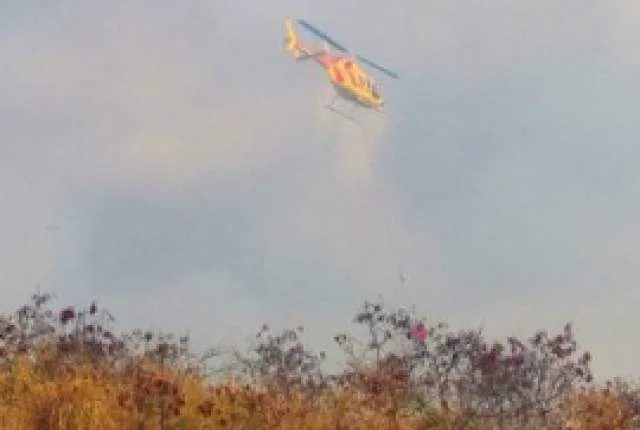
"The Waikoloa area is a step closer to having a new series of dip tanks to help helicopters battle wildfires.
As many as five tanks would support aerial firefighting in areas that have long been recognized as particularly prone to wildland blazes, according to a recent draft environmental assessment. The project has been in the works for the greater part of a decade.
High winds and dry brush and grass make quick helicopter response vital to keep fires from spreading out of control, said Elizabeth Tickett, executive director for the Hawaii Wildfire Management Organization, based in Waimea. The group has applied for federal funding for the tanks and a program to clear flammable brush and grass around Waikoloa Village and Puako.
“Fire suppression is extremely difficult because a lot of things aren’t totally in place,” Tickett said. “We’re limited in water resources. And with such high winds, fires get really big fast.”
But the amount of money available from the Federal Emergency Management Agency — plus the actual number of the 12-foot diameter tanks that might be installed and when — is not yet clear. Once the organization knows how much federal funding it will receive, the nonprofit can work out how much more it needs to raise locally, Tickett said. The tanks cost around $18,000 each, according to bids from two years ago.
The 6,700-gallon tanks would hold water for firefighting and for livestock to be brought into new areas to graze down vegetation. The water would also be used to help fire-resistant native vegetation take root.
Dip tanks are being proposed for Waikoloa Village, Kuainiho, the 1859 lava flow, Ponoholo and Lalamilo. Ongoing maintenance will fall to a variety of local partners.
The Hawaii Wildfire Management Organization — made up of numerous individuals involved in fire suppression on the local and state level — has worked closely with the Hawaii County Fire Department to determine the best sites for the tanks, Tickett said.
Fire Chief Darren Rosario said the dip tanks provide a safer and more abundant source of water for helicopters than the agency’s “frog ponds,” which are 1,000-gallon portable containers that are set up near roadways and replenished with tankers.
“Dip tanks, strategically located, provide the greatest opportunity for us if a fire starts in an area that is inaccessible or located on an unimproved road,” Rosario said. “It takes a great deal of time to deploy our ground troops. The tanks allow our aircraft to get water on a fire on a much shorter turnaround.”
FEMA has indicated it will provide funds at the level of the original application, which dates back to 2006 — provided the EA process is followed through to completion. It’s not clear how much construction that would buy in today’s dollars.
The Waikoloa Village tank would be located in a 275-acre preserve managed by the Waikoloa Dryland Forest Initiative. Jen Lawson, initiative executive director, called the tank a win-win for fire suppression and for the 35 native species her group propagates.
“We’re trying to replace the nonnative grassland, which is the worst fire danger you can have out there,” said Lawson, who has focused on planting wiliwili and uhiuhi trees.
The Kuainiho tank would be placed on land the state Division of Forestry and Wildlife is currently managing for fire control along Highway 190. The tank at the 1859 lava flow would be located in the state Puuanahulu Game Management Area.
The Ponoholo tank is proposed for an area of privately owned ranch land to the northwest of the Kohala Ranch housing development. The Lalamilo tank would be located on state land being leased for ranching southwest of Waimea. Both locations had archaeological sites identified in the EA. Ponoholo and Lalamilo are not included in an alternative plan for the overall project because they would require the presence of an archaeologist during the installation process — a significant cost increase. No historical sites would be affected at the other locations, the EA found.
The Waikoloa fuel break would clear an area 0.5 miles long and 30 feet wide on the southern end of Waikoloa Village, on land owned by the village association, tying into an existing break near Pua Melia Street. Haole koa and fountain grass pose fire threats in the area.
In Puako, the clearing of brush, grading and mulching would take place in an area 2 miles long and 100 feet wide along the mauka side of Puako Beach Road, where dense, highly flammable kiawe forests and buffelgrass pose fire threats on state land.
West Hawaii has some of the most fire prone sites in the state. Native dryland forest sites — historically one of the most diverse ecosystems in the state — are imperiled, and only about 10 percent of original habitat still exists, according to the EA. Unlike some mainland ecosystems, Hawaii’s plants are not adapted to periodic fire, and invasive species have created large fuel loads that can easily ignite.
The EA is available at fema.gov/media-library/assets/documents/93430."