News Center — Hawaii Wildfire Management Organization

climate change

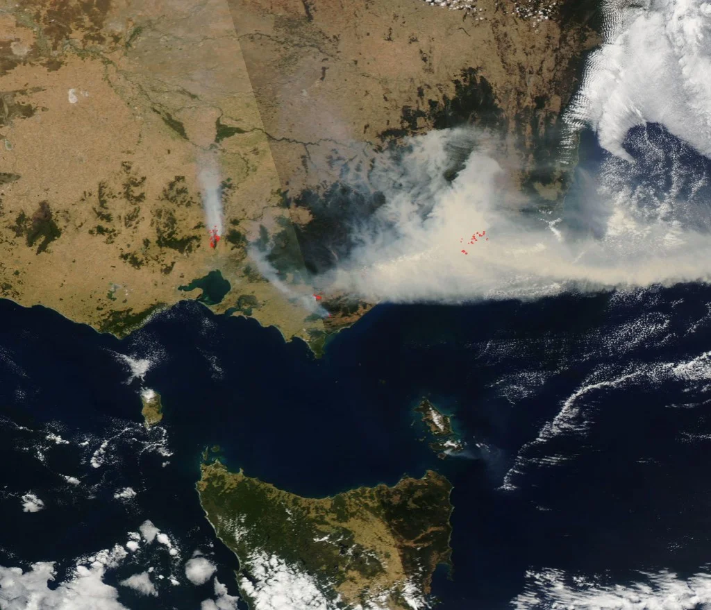
Funny River Fire Darkens Sky Over Kenai Peninsula

"It's pretty scary. This is a first for me, I've been here 15 years but haven't seen anything like this."

This is a line we are hearing over and over again from across the nation and it should be taken seriously. Fire conditions and behavior are rapidly changing and need to be addressed with the same kind of swiftness.

From the Source: 

"The Funny River Fire has grown to more than 20,000 acres, according to a Wednesday morning update from the Alaska Interagency Coordination Center.

Fire came close to but did not cross Funny River Road on the north flank of the fire overnight thanks to fire crews, air support and an existing fuel break, according to the Alaska Interagency Incident Management Team’s Facebook page. 

Firefighters are focusing on securing the north flank on Funny River and the southwest corner to safeguard the community of Kasilof, the update says. Significant smoke is blanketing Soldotna...

At the Kasilof Mercantile Store near milepost 109 on the Sterling Highway, Nancy Russell said it was bright and sunny as she drove to work at 6 a.m. Tuesday. But by 11 a.m., the sky started to cloud with smoke, and it was dark by 2 p.m., she said.

Customers brought in 'horrible' photos of the smoke throughout the day, Russell said. She said people were picking up their children from school early and taking animals to safety.

'People are on very high alert,' she said. 'It's pretty scary. This is a first for me, I've been here 15 years but haven't seen anything like this.'"

Above: "The Funny River wildfire near Soldotna more than doubled in size on Tuesday, May 20, 2014, growing to nearly 7,000 acres in dry, windy conditions and low humidity, fire officials said." Credit: Bill Roth/Anchorage Daily News

Above: "The Funny River wildfire near Soldotna more than doubled in size on Tuesday, May 20, 2014, growing to nearly 7,000 acres in dry, windy conditions and low humidity, fire officials said." Credit: Bill Roth/Anchorage Daily News

Drought, Fire, and the New Normal in the American West

From the Source: 

"The wildfire season arrived early this week in southern California, at a time of the year when skies usually are covered in cooling clouds of gray.

But this spring, the skies have been more like ashen gray, and fire agencies have responded to nearly 1,400 fires this year—twice the typical number, a Cal Fire spokesperson told the Los Angeles Times. A New York Times report May 16 said fire season in the West is now 75 days longer each year than it was a decade ago.

At the root of the problem is the deep, three-year drought that continues to plague California, and warmer winter weather that shrinks the snowpack in the Cascade and Sierra Mountains—a recipe that increases likelihood of wildfires. Studies indicate that the number and size of Western fires is up, and scientists say this drought may be the start of a long-term trend, noting that other Western droughts during the past 1,000 years have been more severe and could repeat." 

Above: "Firefighters drive through a burned-out area in the hills around San Marcos, California, on May 15, 2014." Credit: Mike Blake/Reuters

Above: "Firefighters drive through a burned-out area in the hills around San Marcos, California, on May 15, 2014." Credit: Mike Blake/Reuters

Wildfires are Growing, and Growing More Costly (VIDEO)

From the Source: 

"The wildfires raging across California are the latest example of a grim reality: Wildfires are getting more dangerous, and they're costing us more, too.

U.S. taxpayers are paying about $3 billion a year to fight wildfires—triple what it cost in the 1990s—and big fires can lead to billions of dollars in property losses.

The bad news: It's going to get worse.

Researchers say a potent combination of climate change and homebuilding near wildfire-prone areas is already translating into bigger, longer, more dangerous fires, and none of those trends are showing signs of letting up."

Above: "Flames near a house in Carlsbad, Calif., May 14, 2014." Credit: Daniel Knighton/Getty Images

Above: "Flames near a house in Carlsbad, Calif., May 14, 2014." Credit: Daniel Knighton/Getty Images

Firefighters Wary of Hot Winds Fanning San Diego-Area Wildfire

From the Source: 

"Hundreds of firefighters were battling Wednesday to contain a San Diego wildfire, concerned that California's so-called devil winds would ignite flareups, authorities said.

Authorities were concerned that hot, dry gusts called Santa Ana winds would set back their efforts since Tuesday morning to contain the wildfire, which improved overnight to 25% from 5%, said Cal Fire incident commander Ray Chaney.

The fire has burned 1,584 acres and prompted an evacuation Tuesday of 5,000 homes in San Diego and selected areas, authorities said. By Tuesday night, those residents had an "orderly return" to their homes, San Diego Police Chief Shelley Zimmerman said...

'It has been, to say the least, a very challenging day for local fire agencies and law enforcement agencies,' San Diego Fire Chief Javier Mainar said. 'It is unusual in May to have wind-driven fires like this that prove to be such a challenge to contain.'

Michel agreed, saying there's a long, hot summer ahead. 'This is going to be a pretty severe fire season,' he said. 'We're in a prolonged drought.'" 

Above: "A helicopter drops water near the Rancho Santa Fe neighborhood of San Diego on Tuesday, May 13. A wildfire forced the evacuation of more than 20,000 homes in Southern California, officials said, as a high-pressure system brought unseasonable…

Above: "A helicopter drops water near the Rancho Santa Fe neighborhood of San Diego on Tuesday, May 13. A wildfire forced the evacuation of more than 20,000 homes in Southern California, officials said, as a high-pressure system brought unseasonable heat and gusty winds to the parched state." Credit: Stuart Palley/EPA/Landov

Winds Whip Up Calif. Wildfire That has Charred at Least 1,000 Acres (PHOTOS, VIDEO)

From the Source: 

"A fresh blast of strong winds hit a wildfire on Thursday in the foothills east of Los Angeles but did not spread the blaze that drove people from 1,600 homes, officials said.

The fire remained within the previous burn area despite new winds that reached 60 mph, the U.S. Forest Service said.

The winds still brought trouble, however, forcing the grounding of helicopters and planes that were being used to fight the fire that began Wednesday in San Bernardino National Forest.

The lack of aircraft also prevented an accurate mapping of the blaze that has charred at least 1,000 acres and likely many more, the Forest Service said.

The fire was 10 percent contained after an initial surge on Wednesday that included a gust of winds that topped 100 mph...

'The message is, 'ready, set, go,'' said Rancho Cucamonga Fire Chief Mike Bell. "Be ready just in case something changes.'...

California usually has about 500 wildfires by May. But this year there have already been more than 1,000, with the start of the fire season still a month away."

Above: "Bert Newman sprays water on his home as a wildfire driven by fierce Santa Ana winds closes in on him in Rancho Cucamonga, California, April 30, 2014. Credit: David McNew/Reuters" 

Above: "Bert Newman sprays water on his home as a wildfire driven by fierce Santa Ana winds closes in on him in Rancho Cucamonga, California, April 30, 2014. Credit: David McNew/Reuters" 

Wildfires in West Increasing Burn Areas at Nearly One Denver Per Year, Study Finds

From the Source: 

"Just as wildfire season is getting off to a heated start, a new study has found that in the last 30 years in the western United States, both the number of fires and the area that they burn have increased. The study, published by the American Geophysical Union, looked at the 17-state region stretching from Nebraska to California. It found that wildfires over 1,000 acres in size increased by about seven fires a year from 1984 to 2011. It also found that the amount of area these fires burned increased each year at about 140 square miles, or 90,000 acres, per year — an area about the size of Las Vegas and nearly the size of Denver.

The researchers assert that these trends are likely due to climate change and associated shifts in rain patterns and temperature norms, rather than local factors. The study does not directly link the findings to human-caused climate change, but it says the observations fit well with the predictions of climate models for the region.

“We looked at the probability that increases of this magnitude could be random, and in each case it was less than one percent,” Philip Dennison, an associate professor of geography at the University of Utah in Salt Lake City and lead author of the paper, said in a statement.

This is the first study to utilize high-resolution satellite data to look at wildfire trends across a variety of landscapes and ecoregions, according to the researchers. They used nine ecoregions, including forested mountains, deserts, and grasslands, and found that the rise in fire activity was strongest in areas like the Rocky Mountains, the southwest desert, and the southern plains in Texas, Oklahoma, and Kansas. According to Dennison, these are the same regions that would be expected to experience more fire activity due to climate change."

Above: Courtesy of AP/Jae C. Hong

Above: Courtesy of AP/Jae C. Hong

Cal Fire Begins Defensible Space Inspections Early Because of Drought (VIDEO)

It's never too early to take preventative measures, especially considering the predicted giant wildfire season this year. Contact us at Hawaii Wildfire if you would like us to conduct a defensible space home assessment.  

From the Source:

"Cal Fire has battled more than 650 fires so far this year, more than triple the average, as a result of the dry conditions from the drought.

Normally, the total number of fires in January and February is 200, according to Cal Fire.

Cal Fire started inspecting homes in high-risk areas this week, ensuring people are maintaining at least 100 feet of defensible space around their homes.

'This year, we’re doing that several months earlier because of that increased fire threat that we’ve been seeing across the state,' spokesman Daniel Berlant said.

Fire inspectors are asking people to remove flammable vegetation, space out trees and plants and trim branches, among other things, to create a buffer zone around their homes and to help out firefighters."

Above: Courtesy of KCRA

Above: Courtesy of KCRA

Rains Ease California Drought, Make Wildfire Outlook Grimmer

Hawai'i is facing a similar issue, especially on the leeward sides. The lush greens emerging from mauka to makai may look beautiful, but once they dry out, they will become large loads of fuel for potential wildfires.

From the Source:

"The cruel irony is that the much-needed moisture may end up making a wildfire season expected to be catastrophic even worse than it would have been if the region had stayed completely dry. 

'The initial impact will be to dampen the immediate impact of fires,' said Drought Monitor author Brad Rippey, a meteorologist for the U.S. Department of Agriculture in Washington, D.C.. 'But this rain will be enough to promote spring growth of vegetation that may otherwise have been dormant because of the drought. There may actually be more to burn, at least the lighter fuels, than if it had stayed dry all the way through.'

Grasses will sprout and grow because of the rains, then they’ll quickly dry out and provide easy fuel for a major wildfire, he said."

Above: Courtesy of U.S. Drought Monitor

Above: Courtesy of U.S. Drought Monitor

Geographer: Drought, Fires Impact Ability of Amazon to Hold Carbon Dioxide

From the Source:

"Fires in the Amazon could jeopardize the forest's ability to soak up carbon dioxide emissions even as deforestation there slows down, according to a Penn State geographer. In an invited commentary in the Feb. 6 edition of Nature, Jennifer Balch, assistant professor of geography, noted that dry weather conditions, coupled with fires, may mean that over time the Amazon forest will lose its ability to take in more carbon dioxide than it releases — going from being a carbon sink to a source."

Above: "Fires in the Amazon, such as this pasture blaze in the Brazilian state of Mato Grosso, may swamp the forest's ability to take in more carbon dioxide than land use releases, according to Penn State geographer Jennifer Balch." - Penn State News

Above: "Fires in the Amazon, such as this pasture blaze in the Brazilian state of Mato Grosso, may swamp the forest's ability to take in more carbon dioxide than land use releases, according to Penn State geographer Jennifer Balch." - Penn State News

California's Drought Heightens Fear of Fire Season

From the Source:

"There is no relief in sight from the historic drought ravaging every corner of California, and where there's drought, there's fire. In the thick of winter and normally wet months, 545 fires have broken out so far this year, burning 1,142 acres.

That is a staggering 330 percent increase in fires over the same Jan. 1 to Feb. 15 period last year and a 150 percent jump in burned acreage...

Current conditions are as severe as during the hottest summer months, and Cal Fire is bracing for the worst. It has already brought in 125 additional firefighters, who normally come on board when fire season starts in late May in the North and in June in Southern California...

There is enough water to fight fires now, [Capt. Michael] Mohler said, but he added a note of warning to the state’s residents and urged them to conserve supplies. 
We’re reminding California residents that not only is it important to save water for the environment and human consumption but for firefighting,' he said."

Above: "Firefighters being deployed as wildfires burn through the foothills in Azusa, Calif., in January." - Al-Jazeera America

Above: "Firefighters being deployed as wildfires burn through the foothills in Azusa, Calif., in January." - Al-Jazeera America

Western Wildfire Season 'Likely to Set a Record'

From the Source:

"The number of wildfires has increased over the years. In the 1980s, wildfires burned on average 2.98 million acres a year in the U.S. However, between 2003 and 2012, an average of 7.26 million acres burned each year.

The average length of the annual fire season has grown by 78 days over the last four decades.

Also almost certain to grow is the cost of battling wildfires. National costs have averaged $1.8 billion annually for the past five years, and the 2012 fire season was among the most expensive on record for many regions and states, according to Headwater Economics, a nonprofit research group...

'Because they aren't getting any water, the trees are in danger and won't survive, creating more fuel for fires,' [Malcolm North, a research ecologist with the U.S. Forest Service] said.

North added that the level of destruction this year's fire season brings will depend a lot on luck.

'All we can do is hope for more rain and hope we get some," he said. "But we've had years of dry conditions, so it will take a lot of rain for a long time to prevent the fires.'"

Above: "Firefighters monitor the Colby Fire on Highway 39, January 17, 2014, in Azusa, California." Courtesy of CNBC.

Above: "Firefighters monitor the Colby Fire on Highway 39, January 17, 2014, in Azusa, California." Courtesy of CNBC.

Devastating Australian Brushfires as Seen from Space

From the Source:

"Bushfires are continuing to rage across parts of Australia’s state of Victoria today despite the arrival of milder conditions.

You can see them in the image [on the left] from NASA’s Aqua satellite. Massive plumes of smoke stream from fires burning in the eastern part of the state, as well as just north of the city of Melbourne. Red dots mark spots where the satellite sensor detected fire...

The region has been experiencing hot and windy conditions that have raised the fire risk in Victoria to its highest level since 2009, when fires killed 173 people."

Above: "NASA’s Aqua satellite captured this view of bushfires blazing in the Australian state of Victoria today. (Source: NASA)" - Discover

Above: "NASA’s Aqua satellite captured this view of bushfires blazing in the Australian state of Victoria today. (Source: NASA)" - Discover

Conservation is No Joke in Drought-Ridden California

The case for more drought-tolerant (and Firewise) landscaping has never been clearer. Hawaii is also suffering from drought conditions, so the lessons from California can certainly apply here. 

From the Source:

"Landscape irrigation accounts for more than 50 percent of water used by a single-family residence, according to Sarah Foley, deputy director of the California Urban Water Conservation Council.

'This is why so much effort is being made now on reduction of outdoor use,' she said in an email to Al Jazeera.

'That’s really the biggest area that needs to be changed,” said Brostrom, of the state’s Department of Water Resources. “It hasn’t been emphasized enough. People will think of taking shorter showers, but when sprinklers go off, they’re the equivalent of 20 shower heads in their yards.'" 

Above: "Low-flow shower heads and shorter showers have been common for three decades."

Above: "Low-flow shower heads and shorter showers have been common for three decades."

Brushfires in Australia Deadlier, More Destructive and Worse to Come (VIDEO)

From the Source:

"BUSHFIRES are almost twenty times more deadly and eighty times more destructive than a century ago - and experts warn the devastation will continue to grow as urban sprawl pushes further into bushland. Exclusive analysis by News Corp Australia has revealed the true extent of the devastating toll caused by decades of bushfires.

In today's money, the combined damage caused by bushfires over the past 90 years is almost $7 billion.

And $2.6 billion of this damage was caused in the past 13 years."

Above: "Harmful effect ... Sydney’s CBD is shrouded in a haze of smoke from bushfires in Springwood, Winmalee and Lithgow in the Blue Mountains last October. Picture: Getty Source: Getty Images"

Above: "Harmful effect ... Sydney’s CBD is shrouded in a haze of smoke from bushfires in Springwood, Winmalee and Lithgow in the Blue Mountains last October. Picture: Getty Source: Getty Images"

Wildfire Rages in Forest Outside of Los Angeles, Residents Evacuated (VIDEO)

Driest year in California's recorded history and notorious Santa Ana winds create a recipe for an early fire season - a VERY early fire season.

From the Source:

"GLENDORA, Calif. » Homes burned in a wildfire threatening neighborhoods in dangerously dry foothills of Southern California's San Gabriel Mountains today, fanned by gusty Santa Ana winds that spit embers into the city below. Residents who awakened in the pre-dawn darkness to see flames approaching were ordered to evacuate.

Television images showed several structures engulfed in flames in a neighborhood abutting Angeles National Forest, just north of the San Gabriel Valley community of Glendora. Homes are nestled in canyons and among rugged ridges that made an accurate assessment difficult.

At least 2 1/2 square miles of dry brush were charred in the wilderness area about 25 miles northeast of downtown Los Angeles...

The notorious Santa Anas, linked to the spread of Southern California's worst wildfires, picked up at daybreak. The extremely dry Santa Anas blow downslope and can push fires out of the mountains and into communities below. The area, which has been historically dry, has been buffeted by the winds which have raised temperatures into the 80s. The Santa Anas typically begin in the fall and last through winter into spring. A wet winter reduces fire risk, but the whole state is experiencing historically dry conditions."

Above: "A wildfire burned in the hills just north of the San Gabriel Valley community of Glendora, Calif. today. Southern California authorities have ordered the evacuation of homes at the edge of a fast-moving wildfire burning in the dangerously dr…

Above: "A wildfire burned in the hills just north of the San Gabriel Valley community of Glendora, Calif. today. Southern California authorities have ordered the evacuation of homes at the edge of a fast-moving wildfire burning in the dangerously dry foothills of the San Gabriel Mountains." - Associated Press

Warm Weather, Low Humidity Raise Wildfire Risk in San Diego County

Extreme summer-like winter conditions in Southern California are extending the fire season. Article demonstrates a good example of the conditions that create extreme fire behavior:

From the Source:

"'A combination of strong winds, low relative humidity, above normal temperatures and very low fuel moisture will contribute to extreme fire behavior,' the NWS said."

"NWS forecasters said the lack of rainfall this winter had further dried vegetation well beyond what was normal for this time of year in many areas."

"This National Weather Service map shows in pink the areas under a red flag warning beginning Monday, Jan. 13, 2014." - Courtesy of KPBS

"This National Weather Service map shows in pink the areas under a red flag warning beginning Monday, Jan. 13, 2014." - Courtesy of KPBS

Record Driest Year in California, Parts of Oregon

California is experiencing unusual winter fires given the driest conditions the region has experienced in its recorded history - normally wet areas like Big Sur, for example, are ablaze. These conditions aren't unique to California, as Hawaii has experienced record-breaking drought conditions over the last few years, spurring an increase in the frequency, size, and severity of fires across all of the islands. 

From the Source:

“California and parts of western Oregon witnessed their driest year on record in 2013, according to statistics from the National Weather Service (NWS)...

A critical season looms for the nation's most populous state, struggling through its third straight dry winter.

The culprit for this dearth of rain and mountain snow is a persistent ridge of high pressure aloft over the eastern north Pacific Ocean, which has diverted the jet stream, and hence, the storm track, well to the north into Canada. 

The few storm systems that have penetrated the West Coast recently have tended to drop south out of western Canada as relatively moisture-starved systems, rather than sweeping in ashore from west to east, tapping deeper moisture. 

Are there any signs of the pattern turning wetter? In a word, 'no'."

Article link no longer exists.

Above: "Drought status of the western U.S. as of Dec. 24, 2013. Areas of worse drought are indicated by the progressively more tan/brown contours. (NOAA/USDA/NDMC)."

Above: "Drought status of the western U.S. as of Dec. 24, 2013. Areas of worse drought are indicated by the progressively more tan/brown contours. (NOAA/USDA/NDMC)."

The Age of Western Wildfires

From the Source:

"The cooler temperatures of fall may have arrived on the East Coast, but in California and the Pacific Northwest, fire season burns on. There are six large fires raging out West, and this year’s season is likely to burn 10 million acres of land, more than in any year since 1960, when federal records began to be kept.

Explanations abound: global warming has provided consistently hotter weather, and warmer winters have meant less snow melt during the spring. Drought has plagued the country, and invasive beetles have killed millions of trees, leaving mountains of ready-to-burn timber." 

Powered by Squarespace