News Center — Hawaii Wildfire Management Organization

fire science

Fighting Wildfire with Satellites, Lasers and Drones

How technology is improving the ability to spot out wildfires - the challenge: getting that "information into the hands of the firefighters."

From the Source: 

"Fire lookout technology has changed a lot since Jack Kerouac’s Desolation Angels. The book was taken almost entirely from a diary Kerouac kept when he was fire lookout for 63 days on Desolation Peak in Washington. Now, satellite images, fuel analysis, and, soon, the use of drones, are among the high-tech methods for protecting wilderness and civilization from wildfires.

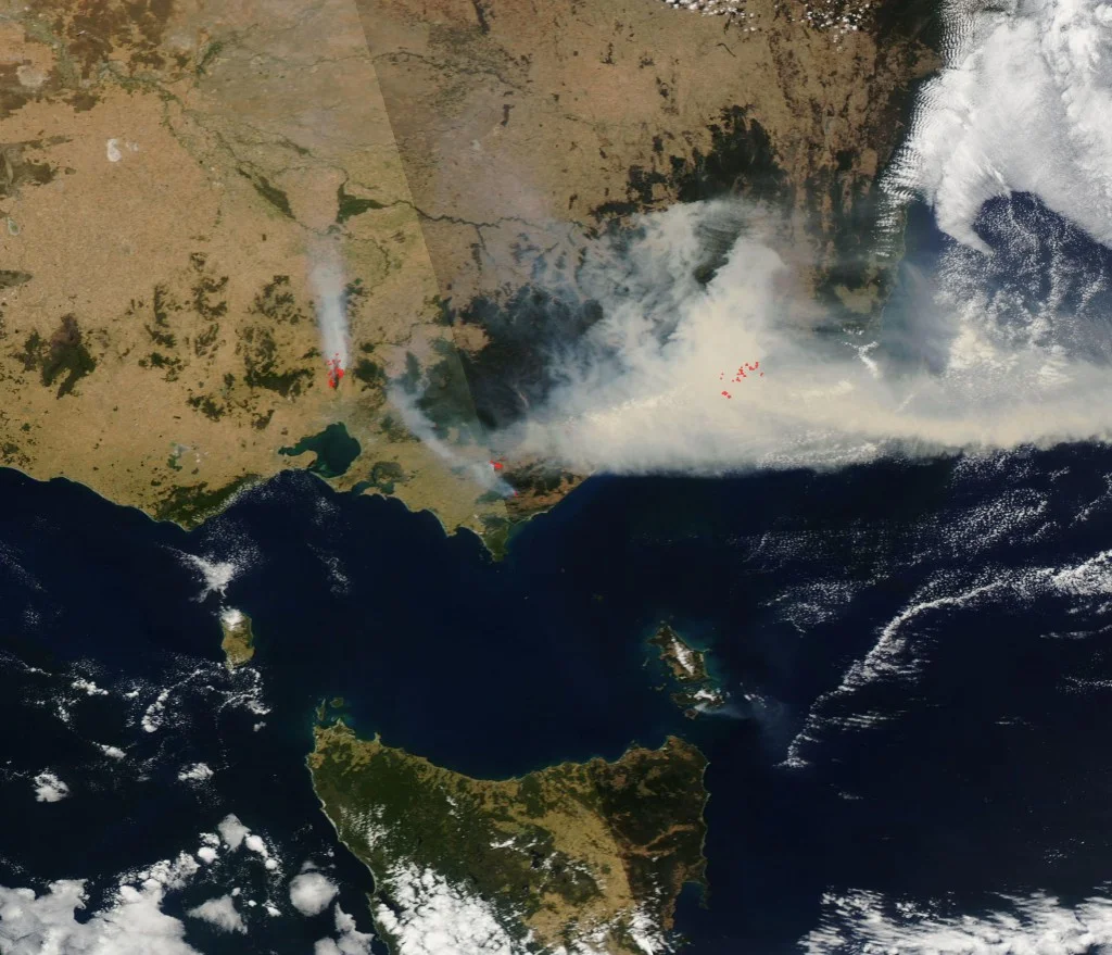
Some of the more important real-time fire data comes from MODIS, a sensor on two NASA satellites that view the entire Earth’s surface every one to two days. The sensors show heat sources (that’s how a fire was first spotted in Noatak, Alaska by a fire manager looking at the data in the early 2000s). It was the first time a fire had been detected by satellite before humans noticed it, says Sean Triplett, the group leader for geo-spatial and information management at the U.S. Forest Service.

'Alaska is huge,' Triplett says. 'It’s a long flight from one side of the state to the other. MODIS was really able to allow us to cover the whole state really quickly, since it sees a larger area.'

After a fire, the U.S. Geological Survey’s LANDSAT satellite can be used to determine the severity of the burn by comparing a pre-fire photo of an area to a post-fire one. The differences in brightness allow scientists to determine the normalized burn ratio, as well as to reflect the changes on the ground."

Above: Credit - David McNew/Getty

Above: Credit - David McNew/Getty

Dad of Fallen Arizona Hotshot Hopes to Make Better Fire Shelters (AUDIO)

Fire shelter improvements unfortunately spurred by the death of the 19 Yarnell Hill firefighters:

From the Source: 

"Firefighter Travis Turbyfill was killed one year ago by a wildfire after he and fellow members of the elite Granite Mountain Hotshots deployed to a fire shelter in an Arizona box canyon. A fierce wind blew the Yarnell Hill Fire over the crew, killing 19.

Travis' father, David, doesn't want his son to have died in vain, and he's trying to help the U.S. Forest Service improve those shelters to withstand direct flames. All that remained of the Granite Mountain Hotshots' fire shelters — which are thin layers of foil and insulation designed to help protect firefighters as a fire burns over them — were twisted piles of crumbled aluminum and ash.

David has been conducting tests on new shelter material, and recently presented the results in a video. In it, a large metal pipe shoots fire for 30 seconds onto the current fire shelter material layered over a firefighter's yellow fire-retardant shirt. The shirt material winds up scorched and brittle.

Then he runs the same test, but for a minute longer, over a fireproof fabric Turbyfill found on the Internet. 'The firefighter's shirt is completely intact,' he says as he shows the camera the scorch-free yellow material.

For anyone who's seen a wildfire, the video gets your attention.

Turbyfill's metal fabricating shop is in Prescott, Ariz. There he talks statistics. In the past two decades, burn over and entrapment accounted for 25 percent of wildland firefighter deaths. In the case of the Yarnell Hill Fire, the wind pushed the blaze over the men and trapped them in a canyon.

'What I'm saying is that if you create a better fire shelter or survivable fire shelter product, that you could eliminate 20 to 25 percent of all fatalities. Eliminate. Not reduce, eliminate,' he says."

Above: "This aerial photo shows Yarnell, Ariz., days after a fire claimed the lives of 19 members of an elite firefighting crew." Credit: Tom Tingle / AP

Above: "This aerial photo shows Yarnell, Ariz., days after a fire claimed the lives of 19 members of an elite firefighting crew." Credit: Tom Tingle / AP

66-Million-Year-Old Wildfire Reveals the Climate During the Last Days of the Dinosaurs

From the Source: 

"Archaeologists are learning a bit more about forest fires that occurred 66 million years ago during the time of the dinosaurs. They've discovered the first fossil-record evidence of forest fire ecology in Canada, revealing a bit more about the ancient climate of our planet.


In this case, the researchers managed to discover what is essentially a snapshot of the ecology on Earth at a time when the dinosaurs were on the verge of their mass extinction. The fossil record also reveals a bit more about how forests recovered after a fire.

'Excavating plant fossils preserved in rocks deposited during the last days of the dinosaurs, we found some preserved with abundant fossilized charcoal and others without it,' said Hans Larsson, one of the researchers, in a news release. 'From this, we were able to reconstruct what the Cretaceous forests looked like with and without fire disturbance.'"

"In fact, the plant fossils allowed the researchers to estimate, for the first time, climate conditions for the closing period of the dinosaurs in southwestern Canada. This shows exactly what the ecology was like right before the dinosaurs went extinct." 

Above: "Researchers have discovered the first fossil-record evidence of forest fire ecology in Canada, revealing a bit more about the ancient climate of our planet.This image shows the Las Conchas wildfire in the New Mexico region." Credit: Jay…

Above: "Researchers have discovered the first fossil-record evidence of forest fire ecology in Canada, revealing a bit more about the ancient climate of our planet.This image shows the Las Conchas wildfire in the New Mexico region." Credit: Jayson Coil

How to Read the Mind of a Forest Fire

Very interesting article summarizing the history of fire science in the U.S. and the cool tools today's fire scientists use to predict fire behavior.

From the Source: 

"In a stand of ponderosa pine trees high in the Santa Catalina Mountains overlooking Tucson, Arizona, forest-and-fire ecologist Don Falk squatted with me next to a 100-foot-tall tree born a decade or two before American independence. At the base of the trunk, the tree's thick cinnamon-colored bark gave way to a shallow opening a foot wide and two feet high that looked like a series of successively smaller triangles. Falk ran his hand along the charred edges of the opening and explained what we were looking at: a window into the forest's past, and fire's role in shaping it.

Falk studies fire-scarred trees to understand how frequent, severe, and widespread fires have been in an area, and how those patterns have shifted over the centuries--which is also a key to understanding why some fires are bigger, more unpredictable, and more destructive these days, 'How do you know anything on Earth has changed?' he asks. 'You have to be able to compare it to how things were in the past. This is how we know the history.'"

"'What's being released in a fire is the accumulated capital stored up through years of photosynthesis,' Falk says. 

You're not destroying the carbon, hydrogen, or oxygen molecules. They're just being liberated.' And on a tremendous scale: even a relatively small fire of a couple hundred acres can pump out energy equivalent to the atomic bomb dropped on Hiroshima, and can push a mushroom cloud of hot air, ash, and soot miles into the sky."

"While Falk studies fires to better understand how they have changed over the years and altered the landscape, wildland firefighters study fire as soldiers might analyze enemy capabilities. They catalog mental snapshots of fire behavior they have encountered: how the flames ripped through a grassy canyon or hopped off the ground and leaped into the treetops; the strange calm before a sudden wind shift; the fire tornados that can spin flame in new directions. Early on, a rookie matches these images with what he's learned in training or heard from the veterans."

"'“We are living in a time that is unprecedented, with the extremes we're seeing in temperatures, precipitation, and winds, and with that, the effects are unpredictable,' Bahr says. 'If you don't have that in your slide tray, you aren't going to believe it.'"

"The presence of human structures means that forests and shrublands aren't allowed to burn the way they once did. It’s a problem that keeps getting worse. Because the federal government pays most of the tab for firefighting, local governments don't have as much incentive to regulate development in the most fire-prone areas. Some insurers charge higher premiums if homeowners don't mitigate fire dangers, and more communities are adopting building codes that require landscaping and construction materials that can better withstand wildfire and not carry flames through a neighborhood.

But most community-protection programs are voluntary, with progress outpaced by influx into the wildland-urban interface, and more homes at risk means more firefighters at risk."

Above: "Ecologist Don Falk points out a fire scar on a fallen tree stump." Credit: Brian L. Frank

Above: "Ecologist Don Falk points out a fire scar on a fallen tree stump." Credit: Brian L. Frank

The Bees' Needs: When Forests Burn, Wild Pollinators are Among Nature's First Responders

What's the buzz when it comes to wildfires and bees? This interesting article gives another reason why saving the bees is critical for our ecosystems: post-fire restoration.

From the Source: 

"Over the past 30 years, residents of Montana and neighboring western states have watched and worried as wildfires in their region have grown in both number and intensity. Data collected by the U.S. Forest Service reveal that the average number of fires that burned more than 1,000 acres in Montana and Wyoming has doubled since the 1970s; in Idaho, the number has nearly quadrupled.

And with the increased threat of devastating wildfires comes the increased need to find new ways of fostering biodiversity in their aftermath. That’s why Reese and her supervisor, Laura Burkle, a community ecologist at Montana State, are poking around the wildflowers in a burned-over pine grove on this overcast midsummer day. Much of Burkle’s research focuses on wild pollinators, a group of insects made up largely of the tens of thousands of native bee species that are far different from the honey-makers people usually think of when they hear the word “bee.” For the past few years, she has been looking especially closely at these creatures as part of a larger study on biodiversity’s role in helping landscapes recover after wildfire.

Burkle and many other ecologists have hypothesized that wild pollinators are key to speeding up the process by which burned forests bounce back from barrenness to fecundity. For example, lupine—a wildflower that often pops up on sites recently affected by fire—relies on wild pollinators for reproduction. Once established, the plant’s roots host nitrogen-fixing bacteria that enrich the soil below, paving the way for the sprouting of shrubs and conifer seedlings. Other pollinator-dependent wildflowers and shrubs nourish all manner of woodland creatures, from mice to grizzly bears. (The latter are fond of huckleberries, the fruit of a shrub that relies on bees to carry its pollen.)" 

Above: "Laura Burkle studies the interactions between wild pollinators and wild lands." Credit: Vern Evans

Above: "Laura Burkle studies the interactions between wild pollinators and wild lands." Credit: Vern Evans

Dry Conditions Fuel an Alaska Wildfire That's Bigger Than Chicago

From the Source: 

"Alaska is battling a huge wildfire this Memorial Day. In the last 24 hours the fire has spread to become bigger than Chicago, prompting officials to issue an order for about 900 people as it threatens Alaska’s Kenai Peninsula, a region south of Anchorage. With just 30 percent of the fire’s 243 square miles contained, 1,000 structures have been evacuated.

Large wildfires are familiar to the region, where 1 million acres burn annually, and yet it is unusually early in wildfire season to see a fire of this size, a spokesperson said. Citing “unusually dry conditions” as the cause, the Anchorage Daily News points out the state has had “unseasonably warm spring temperatures.”

But the real culprit for worsening fires is climate change, which boosts optimal conditions like heat, drought, and dry weather. This winter, parts of the country were hit by frigid temperatures while Alaska saw temperatures in the high 40s and 50s and had its all-time warmest January. In other words, Alaska saw spring-like temperatures as early as January and February this year. Some scientists say climate change fuels this extreme jet stream."

Above: Credit - NASA

Above: Credit - NASA

Fire on the Mountain (VIDEO, PHOTOS)

Check out this beautifully put-together new short documentary on the many mysteries of fire, highlighting the Missoula Fire Lab's work in Montana. Definitely worth 10 minutes of your day!

From the Source: 

"Last June, 19 firefighters lost their lives trying to control a blaze near Yarnell, Arizona—the highest death toll for firefighters battling a wildfire in this country since 1933. What went wrong? Is it time to reconsider our approach to fighting fire?"

"Fire is inevitable. You can defer it, but it’s a pay-me-now-or-pay-me-later scenario."

"We’re paying for that blindness now. Across the West, enormous swaths of forest and shrubland are loaded with decades’ worth of built-up fuel. Climate change is compounding the problem: years of drought are turning much of that fuel into tinder; fire season is starting earlier and ending later; bugs are surviving warmer winters and killing vast numbers of trees, increasing the risk that fires will start and spread; and some forests destroyed by fire aren’t growing back, because faster-growing shrub and grass species are taking over before new trees can establish themselves. What it all means is that when fires start, they burn hotter and more destructively than ever before, often killing trees that would have survived less-intense heat."

"The success of fire shelters often depends on where they’re deployed, and on the intensity of the fire. The Granite Mountain Hotshots could not have been in a worse place for deploying their shelters: they were walled in on three sides by rising slopes that would funnel and pull the fire, and surrounded by a six-foot-high tangle of very dry fuel."

"When Marsh saw the fire turn the corner into the bowl, the crew had maybe three or four minutes until the flames would reach them. They picked an area where the vegetation wasn’t as dense and started clearing a spot for their shelters, between two shallow troughs that carry runoff into Yarnell. This was the point at which Marsh radioed his plans, with chain saws audible in the background. His sawyers cut down gamble oak and manzanita, to give the crew at least a small area free of fuels where they could lie down. Other hotshots dragged the branches away from the clearing and lit fires at the perimeter to burn off more fuels and increase the distance between themselves and the main fire when it arrived. In the final moments before the fire closed in, as they had been trained to do, they began to toss all their equipment outside the perimeter of the clearing, especially combustible items such as torches and chain-saw gas and oil. But the fire roared in too fast for them to finish the job. Later, fire-behavior analysis would suggest that it crossed the last 100 yards toward them in 19 seconds, burning at about 2,000 degrees."

Above: "Names of the fallen hotshots, scribbled on a whiteboard in the resource room at the fire station the day of the Yarnell Hill Fire and left untouched ever since." Credit: The Atlantic

Above: "Names of the fallen hotshots, scribbled on a whiteboard in the resource room at the fire station the day of the Yarnell Hill Fire and left untouched ever since." Credit: The Atlantic

The Mysterious Science of Fire (VIDEO)

Check out this beautifully put-together new short documentary on the many mysteries of fire, highlighting the Missoula Fire Lab's work in Montana. Definitely worth 10 minutes of your day!

From the Source: 

"Massive wildfires cost billions of dollars and burn millions of acres in the U.S. every year, but we know surprisingly little about the basic science of how they spread. At the Fire Lab in Missoula, Montana, researchers reverse-engineer spreading fires using wind tunnels, fire-whirl generators, and giant combustion chambers. They're finding that fire is a mysterious phenomenon, and the physics behind it is often counterintuitive." 

Above: Screen capture from The Atlantic video.

Above: Screen capture from The Atlantic video.

Drought, Fire, and the New Normal in the American West

From the Source: 

"The wildfire season arrived early this week in southern California, at a time of the year when skies usually are covered in cooling clouds of gray.

But this spring, the skies have been more like ashen gray, and fire agencies have responded to nearly 1,400 fires this year—twice the typical number, a Cal Fire spokesperson told the Los Angeles Times. A New York Times report May 16 said fire season in the West is now 75 days longer each year than it was a decade ago.

At the root of the problem is the deep, three-year drought that continues to plague California, and warmer winter weather that shrinks the snowpack in the Cascade and Sierra Mountains—a recipe that increases likelihood of wildfires. Studies indicate that the number and size of Western fires is up, and scientists say this drought may be the start of a long-term trend, noting that other Western droughts during the past 1,000 years have been more severe and could repeat." 

Above: "Firefighters drive through a burned-out area in the hills around San Marcos, California, on May 15, 2014." Credit: Mike Blake/Reuters

Above: "Firefighters drive through a burned-out area in the hills around San Marcos, California, on May 15, 2014." Credit: Mike Blake/Reuters

Ahead of Wildfire Season, Scientists Study What Fuels Fire (AUDIO)

A great example of science that meets management needs, which happens to be the state mission for the Pacific Fire Exchange.

From the Source: 

"As fire managers in the drought-stricken Southwest gear up for another long and expensive wildfire season, federal fire scientists are trying to better understand the physics behind what makes blazes spread.
At a U.S. Forest Service fire lab in Riverside, Calif., a team of scientists is conducting daily experiments over the next few months on different fire behavior conditions. They hope to hand off their findings to fire managers, who have to make the quick decisions on where to deploy resources that could protect lives and property.

The centerpiece of the lab is a 30-foot-long, 10-foot-high wind tunnel and inside is a layer of wood shavings meant to mimic a dry, forest floor. Above them, resting on a shelf, are freshly picked green shrubs, the live green trees in this soon-to-be simulated forest fire...

After all, these are the plants that blanket the chaparral hills of Southern California and Arizona, notorious for fueling some spectacular wildfires. But what Weise wants to know are the precise conditions that turned this small blaze into a potentially large one; one that would be almost impossible to control in the field...

'What we're trying to do here is conduct these experiments so that we can produce models, which can be used to perhaps predict what might happen under conditions that might be outside of a manager's experience,' Weise says.

Weise says that with improved models of fire behavior, that fire manager will have a better idea where to put resources to get out in front of the fire. His team plans to conduct these daily experiments under all types of different wind speeds, humidity and types of fuel for a couple more months...

There is a sense of urgency with research like this. It turns out that most of the fire behavior models commonly in practice today are based on research conducted 40 years ago. And there's no indication that wildfires are going to get any less severe anytime soon."

Above: "A lab technician lighting a fire in a wind tunnel at a fire lab in Riverside, Calif." Credit: Sean Nealon/University of California, Riverside

Above: "A lab technician lighting a fire in a wind tunnel at a fire lab in Riverside, Calif." Credit: Sean Nealon/University of California, Riverside

Wildfires in West Increasing Burn Areas at Nearly One Denver Per Year, Study Finds

From the Source: 

"Just as wildfire season is getting off to a heated start, a new study has found that in the last 30 years in the western United States, both the number of fires and the area that they burn have increased. The study, published by the American Geophysical Union, looked at the 17-state region stretching from Nebraska to California. It found that wildfires over 1,000 acres in size increased by about seven fires a year from 1984 to 2011. It also found that the amount of area these fires burned increased each year at about 140 square miles, or 90,000 acres, per year — an area about the size of Las Vegas and nearly the size of Denver.

The researchers assert that these trends are likely due to climate change and associated shifts in rain patterns and temperature norms, rather than local factors. The study does not directly link the findings to human-caused climate change, but it says the observations fit well with the predictions of climate models for the region.

“We looked at the probability that increases of this magnitude could be random, and in each case it was less than one percent,” Philip Dennison, an associate professor of geography at the University of Utah in Salt Lake City and lead author of the paper, said in a statement.

This is the first study to utilize high-resolution satellite data to look at wildfire trends across a variety of landscapes and ecoregions, according to the researchers. They used nine ecoregions, including forested mountains, deserts, and grasslands, and found that the rise in fire activity was strongest in areas like the Rocky Mountains, the southwest desert, and the southern plains in Texas, Oklahoma, and Kansas. According to Dennison, these are the same regions that would be expected to experience more fire activity due to climate change."

Above: Courtesy of AP/Jae C. Hong

Above: Courtesy of AP/Jae C. Hong

Why Homes are Lost to Wildfire: This Forest Service Expert Says it's as Much a Sociopolitical Problem as it is Physical

Very interesting interview with the founder of the Firewise Communities Certification Program. Although some of the content doesn't quite apply to Hawaii, there are many lessons learned to gain from it.

From the Source: 

"Wildland fires are inevitable. And without homeowner engagement, without their participation in mitigating the problem, firefighters can't be effective. It's continuing a problem to have my own agency, federal agencies in general, and most fire departments in this country that deal with wildland fire issues, not be telling people that by and large, under the conditions that destroy lots of houses, we can't deal with this without your participation. It's about taking responsibility for the condition of your house, before the fire, because nobody else can. And it's not just the material that the house is made of, it's the condition that lends itself to potential ignition. It's a big maintenance issue too…

You don't have to eliminate fire from your property completely, but you have to keep flames from contacting your structure and you have to keep firebrands from having high ignition potential when they land on your house - because they will. Which means all of the fine fuels need to be gone from on and immediately around your house before fire season even starts. All flammable things need to be swept away from your house at least about five feet. The grass needs to be mowed immediately around the structure, but you don' t have to mow an acre.

You don't have to cut all the trees down, you just have to make sure they're not contacting each other, and they're not continuous with the wildland. Make sure fire on the surface can't easily burn up the tree and torch out, because that creates firebrands close to the house. I highly encourage hardwoods around the structure as a shield, they just don't support high-intensity fire, and can become a very, very good radiation barrier."

Above: "The wreckage of a burned structure sits near a surviving home after the 2010 Fourmile Canyon Fire near Boulder, Colorado. The 7,000 acre fire claimed nearly 170 houses in the first days of the blaze. Several of the houses that were saved had…

Above: "The wreckage of a burned structure sits near a surviving home after the 2010 Fourmile Canyon Fire near Boulder, Colorado. The 7,000 acre fire claimed nearly 170 houses in the first days of the blaze. Several of the houses that were saved had properly prepared their land for the potential of wildfire, including building with fire resistant materials as well as preparing defensible, fuel-minimized spaces in the areas surrounding the structure." Credit: Matt Slaby/Luceo 

Geographer: Drought, Fires Impact Ability of Amazon to Hold Carbon Dioxide

From the Source:

"Fires in the Amazon could jeopardize the forest's ability to soak up carbon dioxide emissions even as deforestation there slows down, according to a Penn State geographer. In an invited commentary in the Feb. 6 edition of Nature, Jennifer Balch, assistant professor of geography, noted that dry weather conditions, coupled with fires, may mean that over time the Amazon forest will lose its ability to take in more carbon dioxide than it releases — going from being a carbon sink to a source."

Above: "Fires in the Amazon, such as this pasture blaze in the Brazilian state of Mato Grosso, may swamp the forest's ability to take in more carbon dioxide than land use releases, according to Penn State geographer Jennifer Balch." - Penn State News

Above: "Fires in the Amazon, such as this pasture blaze in the Brazilian state of Mato Grosso, may swamp the forest's ability to take in more carbon dioxide than land use releases, according to Penn State geographer Jennifer Balch." - Penn State News

California's Drought Heightens Fear of Fire Season

From the Source:

"There is no relief in sight from the historic drought ravaging every corner of California, and where there's drought, there's fire. In the thick of winter and normally wet months, 545 fires have broken out so far this year, burning 1,142 acres.

That is a staggering 330 percent increase in fires over the same Jan. 1 to Feb. 15 period last year and a 150 percent jump in burned acreage...

Current conditions are as severe as during the hottest summer months, and Cal Fire is bracing for the worst. It has already brought in 125 additional firefighters, who normally come on board when fire season starts in late May in the North and in June in Southern California...

There is enough water to fight fires now, [Capt. Michael] Mohler said, but he added a note of warning to the state’s residents and urged them to conserve supplies. 
We’re reminding California residents that not only is it important to save water for the environment and human consumption but for firefighting,' he said."

Above: "Firefighters being deployed as wildfires burn through the foothills in Azusa, Calif., in January." - Al-Jazeera America

Above: "Firefighters being deployed as wildfires burn through the foothills in Azusa, Calif., in January." - Al-Jazeera America

Western Wildfire Season 'Likely to Set a Record'

From the Source:

"The number of wildfires has increased over the years. In the 1980s, wildfires burned on average 2.98 million acres a year in the U.S. However, between 2003 and 2012, an average of 7.26 million acres burned each year.

The average length of the annual fire season has grown by 78 days over the last four decades.

Also almost certain to grow is the cost of battling wildfires. National costs have averaged $1.8 billion annually for the past five years, and the 2012 fire season was among the most expensive on record for many regions and states, according to Headwater Economics, a nonprofit research group...

'Because they aren't getting any water, the trees are in danger and won't survive, creating more fuel for fires,' [Malcolm North, a research ecologist with the U.S. Forest Service] said.

North added that the level of destruction this year's fire season brings will depend a lot on luck.

'All we can do is hope for more rain and hope we get some," he said. "But we've had years of dry conditions, so it will take a lot of rain for a long time to prevent the fires.'"

Above: "Firefighters monitor the Colby Fire on Highway 39, January 17, 2014, in Azusa, California." Courtesy of CNBC.

Above: "Firefighters monitor the Colby Fire on Highway 39, January 17, 2014, in Azusa, California." Courtesy of CNBC.

Devastating Australian Brushfires as Seen from Space

From the Source:

"Bushfires are continuing to rage across parts of Australia’s state of Victoria today despite the arrival of milder conditions.

You can see them in the image [on the left] from NASA’s Aqua satellite. Massive plumes of smoke stream from fires burning in the eastern part of the state, as well as just north of the city of Melbourne. Red dots mark spots where the satellite sensor detected fire...

The region has been experiencing hot and windy conditions that have raised the fire risk in Victoria to its highest level since 2009, when fires killed 173 people."

Above: "NASA’s Aqua satellite captured this view of bushfires blazing in the Australian state of Victoria today. (Source: NASA)" - Discover

Above: "NASA’s Aqua satellite captured this view of bushfires blazing in the Australian state of Victoria today. (Source: NASA)" - Discover

Brushfires in Australia Deadlier, More Destructive and Worse to Come (VIDEO)

From the Source:

"BUSHFIRES are almost twenty times more deadly and eighty times more destructive than a century ago - and experts warn the devastation will continue to grow as urban sprawl pushes further into bushland. Exclusive analysis by News Corp Australia has revealed the true extent of the devastating toll caused by decades of bushfires.

In today's money, the combined damage caused by bushfires over the past 90 years is almost $7 billion.

And $2.6 billion of this damage was caused in the past 13 years."

Above: "Harmful effect ... Sydney’s CBD is shrouded in a haze of smoke from bushfires in Springwood, Winmalee and Lithgow in the Blue Mountains last October. Picture: Getty Source: Getty Images"

Above: "Harmful effect ... Sydney’s CBD is shrouded in a haze of smoke from bushfires in Springwood, Winmalee and Lithgow in the Blue Mountains last October. Picture: Getty Source: Getty Images"

Warm Weather, Low Humidity Raise Wildfire Risk in San Diego County

Extreme summer-like winter conditions in Southern California are extending the fire season. Article demonstrates a good example of the conditions that create extreme fire behavior:

From the Source:

"'A combination of strong winds, low relative humidity, above normal temperatures and very low fuel moisture will contribute to extreme fire behavior,' the NWS said."

"NWS forecasters said the lack of rainfall this winter had further dried vegetation well beyond what was normal for this time of year in many areas."

"This National Weather Service map shows in pink the areas under a red flag warning beginning Monday, Jan. 13, 2014." - Courtesy of KPBS

"This National Weather Service map shows in pink the areas under a red flag warning beginning Monday, Jan. 13, 2014." - Courtesy of KPBS

Record Driest Year in California, Parts of Oregon

California is experiencing unusual winter fires given the driest conditions the region has experienced in its recorded history - normally wet areas like Big Sur, for example, are ablaze. These conditions aren't unique to California, as Hawaii has experienced record-breaking drought conditions over the last few years, spurring an increase in the frequency, size, and severity of fires across all of the islands. 

From the Source:

“California and parts of western Oregon witnessed their driest year on record in 2013, according to statistics from the National Weather Service (NWS)...

A critical season looms for the nation's most populous state, struggling through its third straight dry winter.

The culprit for this dearth of rain and mountain snow is a persistent ridge of high pressure aloft over the eastern north Pacific Ocean, which has diverted the jet stream, and hence, the storm track, well to the north into Canada. 

The few storm systems that have penetrated the West Coast recently have tended to drop south out of western Canada as relatively moisture-starved systems, rather than sweeping in ashore from west to east, tapping deeper moisture. 

Are there any signs of the pattern turning wetter? In a word, 'no'."

Article link no longer exists.

Above: "Drought status of the western U.S. as of Dec. 24, 2013. Areas of worse drought are indicated by the progressively more tan/brown contours. (NOAA/USDA/NDMC)."

Above: "Drought status of the western U.S. as of Dec. 24, 2013. Areas of worse drought are indicated by the progressively more tan/brown contours. (NOAA/USDA/NDMC)."

Wildfire Science Returns to Rim Fire

From the Source:

"Although dousing the flames was foremost in people's minds during the recent Rim Fire in Stanislaus National Forest and Yosemite National Park, U.S. Geological Survey scientific work continues well after the fire is out. USGS scientists are continuing their critical research characterizing the hidden dangers faced after large wildfires.

While the fire was still smoldering in September, the multi-agency BAER (Burned Area Emergency Response) team developed a burn-severity map and shared it with USGS scientists. USGS assessed the potential for debris flows that tend to occur when the winter rains soak the steep slopes following fires by adding critical information on soil characteristics, the ruggedness of the terrain, and the typical amount of rainfall in that area in order to model the likelihood and possible volumes of debris flows. The just published Rim Fire debris-flow hazards assessment map, will help land and emergency managers focus mitigation treatments on where the greatest damage might be done by post-fire debris flows."

Above: "A recent image from the Landsat 8 satellite in the vicinity of Yosemite National Park, California, during the Rim Fire (August 31). Started on August 17, the Rim Fire had burned over 219,000 acres by August 31 (an area nearly 15 times the si…

Above: "A recent image from the Landsat 8 satellite in the vicinity of Yosemite National Park, California, during the Rim Fire (August 31). Started on August 17, the Rim Fire had burned over 219,000 acres by August 31 (an area nearly 15 times the size of Manhattan Island). Image is false-colored using bands 6, 5, 4 to allow identification of critical vegetation and fuels information that will help firefighters and emergency managers. In the image fire appears bright red, vegetation is green, smoke is blue, clouds are white, and bare ground is tan-colored."

Powered by Squarespace