article header {display: none;}

Fire History

Hawaii State Wildfire History Interactive Map - Geoportal

Hawaii State Wildfire History Interactive Map - Geoportal

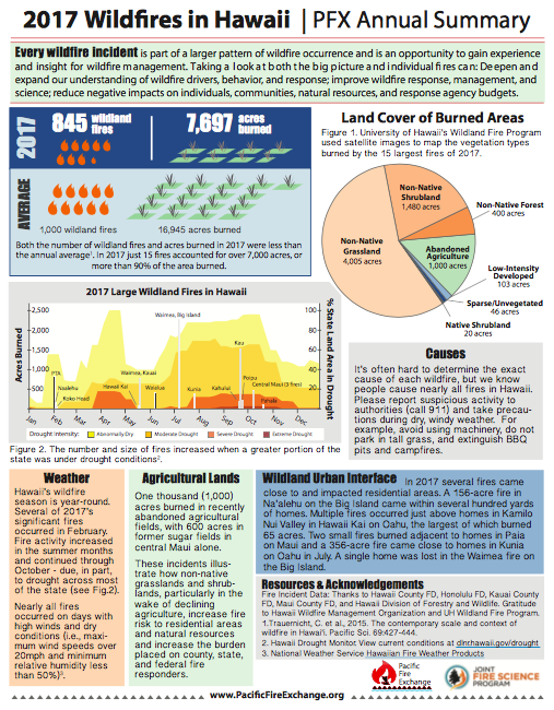
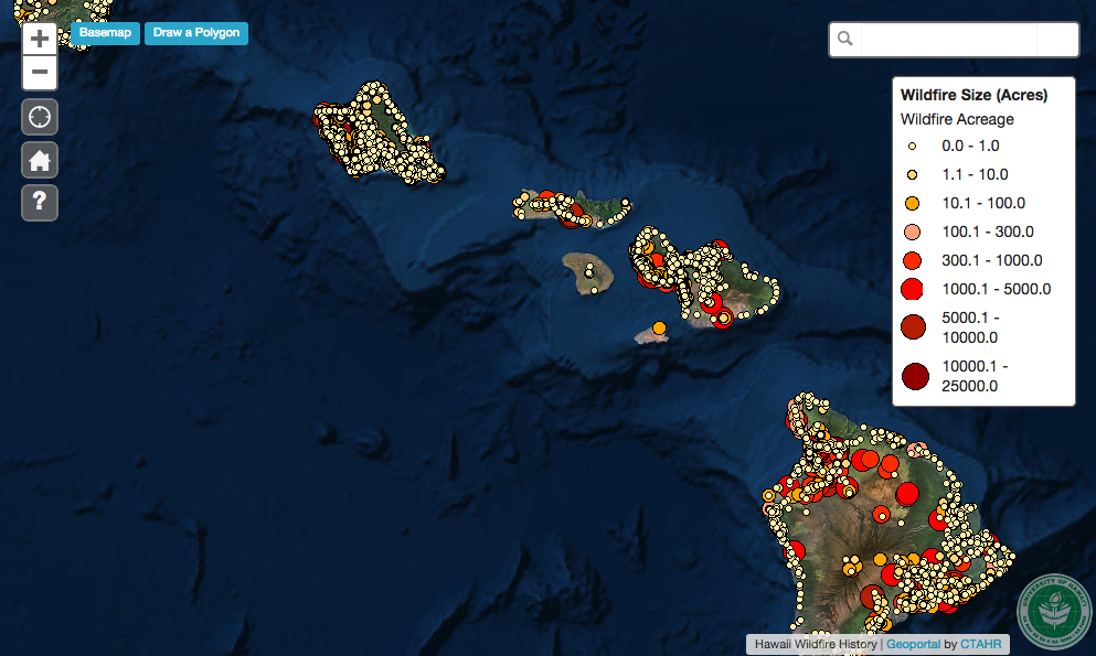
The Hawaii State Wildfire History HWMO spearheaded comes to life in this interactive map, made possible by our friends at UH Manoa, College of Tropical Agriculture and Human Resources (CTAHR). Click around the map to locate wildfires that have occurred from 2002-2011 across the entire state and track down their sizes (acreage burned).

Hawaii Wildfire Interactive Webapp

The Hawaii Wildfire webapp visualizes wildfire data across Hawaii. It has four types of data: fire history, community hazard assessments, community input information, and census data.

State of Hawaii Wildfire History Map (1999-2022)

This is an update to the wildfire incident map published in 2014. HWMO compiled fire event records from federal, state, and local fire agencies from across the board, and then staff spent countless hours putting together these records (1999-2022), checked data, and geo-located each fire. 

2017 Wildfire in Hawaii - PFX Annual Summary

Check out this brand new resource to learn how the wildfire season went in Hawaii in 2017 with this Pacific Fire Exchange fact sheet. Download the full fact sheet by clicking the button below.

"Every wildfire incident is part of a larger pattern of wildfire occurrence and is an opportunity to gain experience and insight for wildfire management. Taking a look at both the big picture and individual fires can: Deepen and expand our understanding of wildfire drivers, behavior, and response; improve wildfire response, management, and science; reduce negative impacts on individuals, communities, natural resources, and response agency budgets."

PFX+Annual+Fire+Summary_2017_6_Elements-05.png

Hawaii Wildfire Impacts Flyer

Hawaii has a devastating wildfire problem. While under-publicized nationally, the scale and scope of wildfires in Hawaii are extreme. Take a look and please share widely!

HWMO VIDEO: Kawaihae Fire and Flood 2015 - Mauka to Makai Impacts

HWMO produced this short PSA video demonstrating the mauka-to-makai effects of wildfire with footage and photographs documenting the post-fire floods in Kawaihae in August 2015, that negatively impacted the nearshore resources including coral reefs.

Fire Management Today - Building a Spatial Database of Fire Occurrence in Hawaii

The article, written by HWMO's Elizabeth Pickett and University of Hawaii's Andrew Pierce, is titled Building a Spatial Database of Fire Occurrence in Hawaii. Ms. Pickett and Dr. Pierce describe the arduous process of collecting, compiling, mapping, and analyzing years of wildfire ignition records from various fire response agencies. 

State of Hawaii Wildfire History Map (2002-2012)

With the help of US Forest Service funding and collaboration with the University of Hawaii, HWMO labored to collect fire event records from federal, state, and local fire agencies from across the board. In the spring of 2013, the HWMO staff spent countless hours putting together a massive spreadsheet with the records that they data checked and geo-located fire by fire. 

Compare Wildfire and Acres Burned

Aggregated US Wildfire statistics limited to starts and acres burned figures.